Valik Chal
Valik Chal
وليك چال | |
|---|---|
village | |
 Valik Chal | |
| Coordinates: 36°05′51″N 53°13′02″E / 36.09750°N 53.21722°E | |
| Country | |
| Province | Mazandaran |
| County | Sari |
| Bakhsh | Dodangeh |
| Rural District | Banaft |
| Population (2006) | |
| • Total | 67 |
| Time zone | UTC+3:30 (IRST) |
| • Summer (DST) | UTC+4:30 (IRDT) |
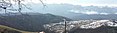
Valik Chal (Persian: وليک چال, also Romanized as Valīk Chāl)[1] is a village in Banaft Rural District, Dodangeh District, Sari County, Mazandaran Province, Iran. At the 2006 census, its population was 67, in 15 families.[2] Valik Chal has views of Alborz Mountain Range and nearby forests. Due to its high altitude (Height above mean sea level: approximately 1500 meters≈5000 feet), Valik Chal experiences relatively cool summers.[citation needed] Winters can be cold and snowy with much rain. Valik Chal has been named after 'Valik', the local word for the fruit 'elderberry', which naturally grows in this village, and 'Chal' the local word for 'valley'. The people of Valik Chal are mainly farmers and ranchers raising crops and cattle.[citation needed]
Gallery
-
 روستای ولیک چال
 -
 منظره ی زیبایی از روستای ولیک چال
 -
 منظره ی زیبایی از روستای ولیک چال
.jpg)

References
- ^ Valik Chal can be found at GEOnet Names Server, at this link, by opening the Advanced Search box, entering "-3837729" in the "Unique Feature Id" form, and clicking on "Search Database".
- ^ "Census of the Islamic Republic of Iran, 1385 (2006)" (Excel). Statistical Center of Iran. Archived from the original on 2011-09-20.
This Sari County location article is a stub. You can help Wikipedia by expanding it. |
- Articles with short description
- Short description is different from Wikidata
- Coordinates on Wikidata
- Articles containing Persian-language text
- All articles with unsourced statements
- Articles with unsourced statements from September 2022
- Populated places in Sari County
- All stub articles
- Sari County geography stubs