Sainte-Brigitte
Sainte-Brigitte
Berc'hed | |
|---|---|
 The church in Sainte-Brigitte | |
.svg) Coat of arms | |
Location of Sainte-Brigitte  | |
 Sainte-Brigitte  Sainte-Brigitte | |
| Coordinates: 48°09′48″N 3°07′40″W / 48.1633°N 3.1278°W | |
| Country | France |
| Region | Brittany |
| Department | Morbihan |
| Arrondissement | Pontivy |
| Canton | Gourin |
| Intercommunality | Pontivy Communauté |
| Government | |
| • Mayor (2020–2026) | Stéphane Du Pontavice[1] |
| Area 1 | 17.74 km2 (6.85 sq mi) |
| Population (2021)[2] | 181 |
| • Density | 10/km2 (26/sq mi) |
| Time zone | UTC+01:00 (CET) |
| • Summer (DST) | UTC+02:00 (CEST) |
| INSEE/Postal code | 56209 /56480 |
| Elevation | 120–286 m (394–938 ft) |
| 1 French Land Register data, which excludes lakes, ponds, glaciers > 1 km2 (0.386 sq mi or 247 acres) and river estuaries. | |
Sainte-Brigitte (French pronunciation: [sɛ̃t bʁiʒit]; Breton: Berc'hed) is a commune in the Morbihan department of Brittany in north-western France.[3]
Population
Inhabitants of Sainte-Brigitte are called in French Brigittois. The population declined quickly after the first world war. The population is steady since 1982.
|
| ||||||||||||||||||||||||||||||||||||||||||||||||||||||||||||||||||||||||||||||||||||||||||||||||||||||||||||||||||
| Source: EHESS[4] and INSEE (1968-2020)[5] | |||||||||||||||||||||||||||||||||||||||||||||||||||||||||||||||||||||||||||||||||||||||||||||||||||||||||||||||||||
Geography
The village centre is located 15 km (9.3 mi) northeast of Pontivy and 62 km (39 mi) north of Vannes. The village is situated at the heart of a hilly and forest-covered region called the Forest of Quenecan.
Map

History
The main activity in the village was the forges in the last centuries. The activity declined quickly at the end of the nineteenth century and the forges closed in 1880.
Gallery
-
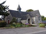 The parish church.
 -
 The bell of the church
 -
 General view of the village of Les Forges des Salles
 -
 Cottages in the village of Le Gouvello


See also
References
- ^ "Maires du Morbihan" (PDF). Préfecture du Morbihan. 7 July 2020.
- ^ "Populations légales 2021" (in French). The National Institute of Statistics and Economic Studies. 28 December 2023.
- ^ INSEE commune file
- ^ Des villages de Cassini aux communes d'aujourd'hui: Commune data sheet Sainte-Brigitte, EHESS (in French).
- ^ Population en historique depuis 1968, INSEE
External links
- Base Mérimée: Search for heritage in the commune, Ministère français de la Culture. (in French)
- Mayors of Morbihan Association (in French)
| International | |
|---|---|
| National | |
This Morbihan geographical article is a stub. You can help Wikipedia by expanding it. |
- Pages using gadget WikiMiniAtlas
- CS1 French-language sources (fr)
- Articles with French-language sources (fr)
- Use dmy dates from August 2023
- Articles with short description
- Short description is different from Wikidata
- Coordinates on Wikidata
- Pages using infobox settlement with image map1 but not image map
- Pages with French IPA
- Articles containing Breton-language text
- Commons category link from Wikidata
- Articles with VIAF identifiers
- Articles with BNF identifiers
- Articles with BNFdata identifiers
- Communes of Morbihan
- All stub articles
- Morbihan geography stubs
- Pages using the Kartographer extension