Saint-Caradec-Trégomel
Jump to navigation
Jump to search
Saint-Caradec-Trégomel
Sant-Karadeg-Tregonvael | |
|---|---|
_%C3%89glise_03.JPG) The parish church in Saint-Caradec-Trégomel | |
Location of Saint-Caradec-Trégomel  | |
 Saint-Caradec-Trégomel  Saint-Caradec-Trégomel | |
| Coordinates: 48°02′18″N 3°21′00″W / 48.0383°N 3.35°W | |
| Country | France |
| Region | Brittany |
| Department | Morbihan |
| Arrondissement | Pontivy |
| Canton | Gourin |
| Intercommunality | Roi Morvan |
| Government | |
| • Mayor (2020–2026) | William Jacobert[1] |
| Area 1 | 16.12 km2 (6.22 sq mi) |
| Population (2021)[2] | 470 |
| • Density | 29/km2 (76/sq mi) |
| Time zone | UTC+01:00 (CET) |
| • Summer (DST) | UTC+02:00 (CEST) |
| INSEE/Postal code | 56210 /56540 |
| Elevation | 99–197 m (325–646 ft) |
| 1 French Land Register data, which excludes lakes, ponds, glaciers > 1 km2 (0.386 sq mi or 247 acres) and river estuaries. | |
Saint-Caradec-Trégomel (Breton: Sant-Karadeg-Tregonvael) is a commune in the Morbihan department of Brittany in north-western France.[3]
Demographics
Inhabitants of Saint-Caradec-Trégomel are called in French Caradocéens.
Geography
Saint-Caradec-Trégomel is border by Le Croisty to the north, by Ploërdut and Lignol to the east, by Kernascléden and Berné to the south and by Priziac to the west. Historically it belongs to Vannetais and Pays Pourlet.
Map

Gallery
-
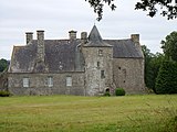 Kermerien castle
 -
 Chapel Saint Cado
 -
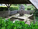 Washing-place in Saint-Caradec


See also
References
- ^ "Maires du Morbihan" (PDF). Préfecture du Morbihan. 7 July 2020.
- ^ "Populations légales 2021" (in French). The National Institute of Statistics and Economic Studies. 28 December 2023.
- ^ INSEE commune file
External links
Wikimedia Commons has media related to Saint-Caradec-Trégomel.
- Base Mérimée: Search for heritage in the commune, Ministère français de la Culture. (in French)
- Mayors of Morbihan Association (in French)
| International | |
|---|---|
| National | |
This Morbihan geographical article is a stub. You can help Wikipedia by expanding it. |
Categories:
- Pages using gadget WikiMiniAtlas
- CS1 French-language sources (fr)
- Use dmy dates from August 2023
- Articles with short description
- Short description is different from Wikidata
- Coordinates on Wikidata
- Pages using infobox settlement with image map1 but not image map
- Articles containing Breton-language text
- Commons category link from Wikidata
- Articles with French-language sources (fr)
- Articles with VIAF identifiers
- Articles with BNF identifiers
- Articles with BNFdata identifiers
- Communes of Morbihan
- All stub articles
- Morbihan geography stubs
- Pages using the Kartographer extension