Meslan
Meslan
Mêlann | |
|---|---|
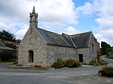
 The parish church in Meslan | |
 Coat of arms | |
Location of Meslan  | |
 Meslan  Meslan | |
| Coordinates: 47°59′42″N 3°25′49″W / 47.995°N 3.4303°W | |
| Country | France |
| Region | Brittany |
| Department | Morbihan |
| Arrondissement | Pontivy |
| Canton | Gourin |
| Intercommunality | Roi Morvan Communauté |
| Government | |
| • Mayor (2020–2026) | Sébastien Wacrenier[1] |
| Area 1 | 37.13 km2 (14.34 sq mi) |
| Population (2021)[2] | 1,456 |
| • Density | 39/km2 (100/sq mi) |
| Time zone | UTC+01:00 (CET) |
| • Summer (DST) | UTC+02:00 (CEST) |
| INSEE/Postal code | 56131 /56320 |
| Elevation | 35–160 m (115–525 ft) |
| 1 French Land Register data, which excludes lakes, ponds, glaciers > 1 km2 (0.386 sq mi or 247 acres) and river estuaries. | |
Meslan (French pronunciation: [melɑ̃]; Breton: Mêlann) is a commune in the Morbihan department of Brittany in north-western France.[3]
Population
Inhabitants of Meslan are called in French Meslannais.
|
| ||||||||||||||||||||||||||||||||||||||||||||||||||||||||||||||||||||||||||||||||||||||||||||||||||||||||||||||||||
| |||||||||||||||||||||||||||||||||||||||||||||||||||||||||||||||||||||||||||||||||||||||||||||||||||||||||||||||||||
| Source: EHESS[4] and INSEE (1968-2020)[5] | |||||||||||||||||||||||||||||||||||||||||||||||||||||||||||||||||||||||||||||||||||||||||||||||||||||||||||||||||||
Geography
Historically it belongs to Vannetais and Pays Pourlet. Apart from the village centre, there are about eighty hamlets. Most of them consist in two or three houses but others are more important like Bonigeard. The river Ellé forms the western border of the commune.
Neighboring communes
Places adjacent to Meslan | |
|---|---|
Map

List of places
|
|
|
|
History
The parish church, placed under the patronage of Saint Mélaine, was rebuilt in 1577. The oldest surviving parish registers date back to 1678. The first mayor of Meslan, Louis Trouboul, was murdered by a gang of chouans on the night of January 9 to 10, 1795.
Monuments
-
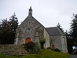
 Chapel of Sainte-Catherine
 -
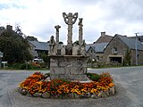 calvary of Bonigeard
 -
 Chapel of Saint-Patern
 -
 Chapel of Saint-Georges
 -
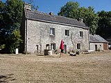 Manor of Kerroualch


See also
References
- ^ "Répertoire national des élus: les maires" (in French). data.gouv.fr, Plateforme ouverte des données publiques françaises. 13 September 2022.
- ^ "Populations légales 2021" (in French). The National Institute of Statistics and Economic Studies. 28 December 2023.
- ^ INSEE commune file
- ^ Des villages de Cassini aux communes d'aujourd'hui: Commune data sheet Meslan, EHESS (in French).
- ^ Population en historique depuis 1968, INSEE
External links
- Official site (in French)
- Base Mérimée: Search for heritage in the commune, Ministère français de la Culture. (in French)
- Mayors of Morbihan Association (in French)
| International | |
|---|---|
| National | |
This Morbihan geographical article is a stub. You can help Wikipedia by expanding it. |
- Pages using gadget WikiMiniAtlas
- Pages using the Graph extension
- Pages with disabled graphs
- CS1 French-language sources (fr)
- Articles with French-language sources (fr)
- Use dmy dates from August 2023
- Articles with short description
- Short description is different from Wikidata
- Coordinates on Wikidata
- Pages using infobox settlement with image map1 but not image map
- Pages with French IPA
- Articles containing Breton-language text
- Commons category link from Wikidata
- Articles with VIAF identifiers
- Articles with BNF identifiers
- Articles with BNFdata identifiers
- Articles with GND identifiers
- Communes of Morbihan
- All stub articles
- Morbihan geography stubs
- Pages using the Kartographer extension