Stephens, Kentucky
Jump to navigation
Jump to search
Stephens, Kentucky | |
|---|---|
 Stephens Location within the state of Kentucky  Stephens Stephens (the United States) | |
| Coordinates: 38°8′7″N 82°57′32″W / 38.13528°N 82.95889°W | |
| Country | United States |
| State | Kentucky |
| County | Elliott |
| Elevation | 628 ft (191 m) |
| Time zone | UTC-5 (Eastern (EST)) |
| • Summer (DST) | UTC-4 (EDT) |
| GNIS feature ID | 509125 |
Stephens is an unincorporated community in Elliott County, Kentucky, United States. It lies along Routes 409 and 486 northeast of the city of Sandy Hook, the county seat of Elliott County.[1] Its elevation is 628 feet (208 m).[2]
References
- ^ Rand McNally. The Road Atlas '06. Chicago: Rand McNally, 2006, p. 43.
- ^ U.S. Geological Survey Geographic Names Information System: Stephens, Kentucky, Geographic Names Information System, 1979-09-20. Accessed 2008-01-03.
Municipalities and communities of Elliott County, Kentucky, United States | ||
|---|---|---|
| City | 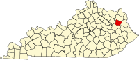 | |
| Unincorporated communities | ||
This Elliott County, Kentucky state location article is a stub. You can help Wikipedia by expanding it. |
Categories:
- Pages using gadget WikiMiniAtlas
- Use mdy dates from July 2023
- Articles with short description
- Short description is different from Wikidata
- Coordinates on Wikidata
- Unincorporated communities in Elliott County, Kentucky
- Unincorporated communities in Kentucky
- All stub articles
- Elliott County, Kentucky geography stubs