Newfoundland, Kentucky
Jump to navigation
Jump to search
Newfoundland, Kentucky | |
|---|---|
 Newfoundland Location within the state of Kentucky  Newfoundland Newfoundland (the United States) | |
| Coordinates: 38°7′53″N 83°5′58″W / 38.13139°N 83.09944°W | |
| Country | United States |
| State | Kentucky |
| County | Elliott |
| Elevation | 643 ft (196 m) |
| Time zone | UTC-5 (EST) |
| • Summer (DST) | UTC-4 (EDT) |
| GNIS feature ID | 508699 |
Newfoundland (also Crackers Neck) is an unincorporated community in Elliott County, Kentucky, United States. It lies along Routes 7 and 32 north of the city of Sandy Hook, the county seat of Elliott County.[1] Its elevation is 643 feet (196 m).[2]
References
- ^ Rand McNally. The Road Atlas '06. Chicago: Rand McNally, 2006, p. 43.
- ^ U.S. Geological Survey Geographic Names Information System: Newfoundland, Kentucky, Geographic Names Information System, 1979-09-20. Accessed 2008-01-03.
Municipalities and communities of Elliott County, Kentucky, United States | ||
|---|---|---|
| City | 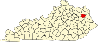 | |
| Unincorporated communities | ||
This Elliott County, Kentucky state location article is a stub. You can help Wikipedia by expanding it. |
Categories:
- Pages using gadget WikiMiniAtlas
- Articles with short description
- Short description is different from Wikidata
- Use mdy dates from July 2023
- Coordinates on Wikidata
- Unincorporated communities in Elliott County, Kentucky
- Unincorporated communities in Kentucky
- All stub articles
- Elliott County, Kentucky geography stubs