Sheoraphuli–Bishnupur branch line
| Sheoraphuli–Bishnupur branch line | ||||||||||||||||||||||||||||||||||||||||||||||||||||||||||||||||||||||||||||||||||||||||||||||||||||||||||||||||||||||||||||||||||||||||||||||||||||||||||||||||||||||||||||||||||||||||||||||||||||||||||||||||||||||||||||||||||||||||||||||||||||||||||||||||||||||||||||||||||||||||||||||||||||||||||||||||||||||||||||||||||||||||||||||||||||||||||||||||||||||||||||||||||||||||||||||
|---|---|---|---|---|---|---|---|---|---|---|---|---|---|---|---|---|---|---|---|---|---|---|---|---|---|---|---|---|---|---|---|---|---|---|---|---|---|---|---|---|---|---|---|---|---|---|---|---|---|---|---|---|---|---|---|---|---|---|---|---|---|---|---|---|---|---|---|---|---|---|---|---|---|---|---|---|---|---|---|---|---|---|---|---|---|---|---|---|---|---|---|---|---|---|---|---|---|---|---|---|---|---|---|---|---|---|---|---|---|---|---|---|---|---|---|---|---|---|---|---|---|---|---|---|---|---|---|---|---|---|---|---|---|---|---|---|---|---|---|---|---|---|---|---|---|---|---|---|---|---|---|---|---|---|---|---|---|---|---|---|---|---|---|---|---|---|---|---|---|---|---|---|---|---|---|---|---|---|---|---|---|---|---|---|---|---|---|---|---|---|---|---|---|---|---|---|---|---|---|---|---|---|---|---|---|---|---|---|---|---|---|---|---|---|---|---|---|---|---|---|---|---|---|---|---|---|---|---|---|---|---|---|---|---|---|---|---|---|---|---|---|---|---|---|---|---|---|---|---|---|---|---|---|---|---|---|---|---|---|---|---|---|---|---|---|---|---|---|---|---|---|---|---|---|---|---|---|---|---|---|---|---|---|---|---|---|---|---|---|---|---|---|---|---|---|---|---|---|---|---|---|---|---|---|---|---|---|---|---|---|---|---|---|---|---|---|---|---|---|---|---|---|---|---|---|---|---|---|---|---|---|---|---|---|---|---|---|---|---|---|---|---|---|---|---|---|---|---|---|---|---|---|---|---|---|---|---|---|---|---|---|---|---|---|---|---|---|---|---|---|---|---|---|---|---|---|---|---|---|---|---|---|
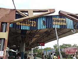
 Kamarkundu railway station lies on Sheoraphuli–Tarakeswar branch line | ||||||||||||||||||||||||||||||||||||||||||||||||||||||||||||||||||||||||||||||||||||||||||||||||||||||||||||||||||||||||||||||||||||||||||||||||||||||||||||||||||||||||||||||||||||||||||||||||||||||||||||||||||||||||||||||||||||||||||||||||||||||||||||||||||||||||||||||||||||||||||||||||||||||||||||||||||||||||||||||||||||||||||||||||||||||||||||||||||||||||||||||||||||||||||||||
| Overview | ||||||||||||||||||||||||||||||||||||||||||||||||||||||||||||||||||||||||||||||||||||||||||||||||||||||||||||||||||||||||||||||||||||||||||||||||||||||||||||||||||||||||||||||||||||||||||||||||||||||||||||||||||||||||||||||||||||||||||||||||||||||||||||||||||||||||||||||||||||||||||||||||||||||||||||||||||||||||||||||||||||||||||||||||||||||||||||||||||||||||||||||||||||||||||||||
| Status | Operational | |||||||||||||||||||||||||||||||||||||||||||||||||||||||||||||||||||||||||||||||||||||||||||||||||||||||||||||||||||||||||||||||||||||||||||||||||||||||||||||||||||||||||||||||||||||||||||||||||||||||||||||||||||||||||||||||||||||||||||||||||||||||||||||||||||||||||||||||||||||||||||||||||||||||||||||||||||||||||||||||||||||||||||||||||||||||||||||||||||||||||||||||||||||||||||||
| Owner | Indian Railways | |||||||||||||||||||||||||||||||||||||||||||||||||||||||||||||||||||||||||||||||||||||||||||||||||||||||||||||||||||||||||||||||||||||||||||||||||||||||||||||||||||||||||||||||||||||||||||||||||||||||||||||||||||||||||||||||||||||||||||||||||||||||||||||||||||||||||||||||||||||||||||||||||||||||||||||||||||||||||||||||||||||||||||||||||||||||||||||||||||||||||||||||||||||||||||||
| Locale | West Bengal | |||||||||||||||||||||||||||||||||||||||||||||||||||||||||||||||||||||||||||||||||||||||||||||||||||||||||||||||||||||||||||||||||||||||||||||||||||||||||||||||||||||||||||||||||||||||||||||||||||||||||||||||||||||||||||||||||||||||||||||||||||||||||||||||||||||||||||||||||||||||||||||||||||||||||||||||||||||||||||||||||||||||||||||||||||||||||||||||||||||||||||||||||||||||||||||
| Termini | ||||||||||||||||||||||||||||||||||||||||||||||||||||||||||||||||||||||||||||||||||||||||||||||||||||||||||||||||||||||||||||||||||||||||||||||||||||||||||||||||||||||||||||||||||||||||||||||||||||||||||||||||||||||||||||||||||||||||||||||||||||||||||||||||||||||||||||||||||||||||||||||||||||||||||||||||||||||||||||||||||||||||||||||||||||||||||||||||||||||||||||||||||||||||||||||
| Stations | 9 | |||||||||||||||||||||||||||||||||||||||||||||||||||||||||||||||||||||||||||||||||||||||||||||||||||||||||||||||||||||||||||||||||||||||||||||||||||||||||||||||||||||||||||||||||||||||||||||||||||||||||||||||||||||||||||||||||||||||||||||||||||||||||||||||||||||||||||||||||||||||||||||||||||||||||||||||||||||||||||||||||||||||||||||||||||||||||||||||||||||||||||||||||||||||||||||
| Service | ||||||||||||||||||||||||||||||||||||||||||||||||||||||||||||||||||||||||||||||||||||||||||||||||||||||||||||||||||||||||||||||||||||||||||||||||||||||||||||||||||||||||||||||||||||||||||||||||||||||||||||||||||||||||||||||||||||||||||||||||||||||||||||||||||||||||||||||||||||||||||||||||||||||||||||||||||||||||||||||||||||||||||||||||||||||||||||||||||||||||||||||||||||||||||||||
| System | Electrified | |||||||||||||||||||||||||||||||||||||||||||||||||||||||||||||||||||||||||||||||||||||||||||||||||||||||||||||||||||||||||||||||||||||||||||||||||||||||||||||||||||||||||||||||||||||||||||||||||||||||||||||||||||||||||||||||||||||||||||||||||||||||||||||||||||||||||||||||||||||||||||||||||||||||||||||||||||||||||||||||||||||||||||||||||||||||||||||||||||||||||||||||||||||||||||||
| Operator(s) | Eastern Railway | |||||||||||||||||||||||||||||||||||||||||||||||||||||||||||||||||||||||||||||||||||||||||||||||||||||||||||||||||||||||||||||||||||||||||||||||||||||||||||||||||||||||||||||||||||||||||||||||||||||||||||||||||||||||||||||||||||||||||||||||||||||||||||||||||||||||||||||||||||||||||||||||||||||||||||||||||||||||||||||||||||||||||||||||||||||||||||||||||||||||||||||||||||||||||||||
| History | ||||||||||||||||||||||||||||||||||||||||||||||||||||||||||||||||||||||||||||||||||||||||||||||||||||||||||||||||||||||||||||||||||||||||||||||||||||||||||||||||||||||||||||||||||||||||||||||||||||||||||||||||||||||||||||||||||||||||||||||||||||||||||||||||||||||||||||||||||||||||||||||||||||||||||||||||||||||||||||||||||||||||||||||||||||||||||||||||||||||||||||||||||||||||||||||
| Opened | 1885 | |||||||||||||||||||||||||||||||||||||||||||||||||||||||||||||||||||||||||||||||||||||||||||||||||||||||||||||||||||||||||||||||||||||||||||||||||||||||||||||||||||||||||||||||||||||||||||||||||||||||||||||||||||||||||||||||||||||||||||||||||||||||||||||||||||||||||||||||||||||||||||||||||||||||||||||||||||||||||||||||||||||||||||||||||||||||||||||||||||||||||||||||||||||||||||||
| Technical | ||||||||||||||||||||||||||||||||||||||||||||||||||||||||||||||||||||||||||||||||||||||||||||||||||||||||||||||||||||||||||||||||||||||||||||||||||||||||||||||||||||||||||||||||||||||||||||||||||||||||||||||||||||||||||||||||||||||||||||||||||||||||||||||||||||||||||||||||||||||||||||||||||||||||||||||||||||||||||||||||||||||||||||||||||||||||||||||||||||||||||||||||||||||||||||||
| Line length | 39 km (24 mi) | |||||||||||||||||||||||||||||||||||||||||||||||||||||||||||||||||||||||||||||||||||||||||||||||||||||||||||||||||||||||||||||||||||||||||||||||||||||||||||||||||||||||||||||||||||||||||||||||||||||||||||||||||||||||||||||||||||||||||||||||||||||||||||||||||||||||||||||||||||||||||||||||||||||||||||||||||||||||||||||||||||||||||||||||||||||||||||||||||||||||||||||||||||||||||||||
| Track gauge | 5 ft 6 in (1,676 mm) broad gauge | |||||||||||||||||||||||||||||||||||||||||||||||||||||||||||||||||||||||||||||||||||||||||||||||||||||||||||||||||||||||||||||||||||||||||||||||||||||||||||||||||||||||||||||||||||||||||||||||||||||||||||||||||||||||||||||||||||||||||||||||||||||||||||||||||||||||||||||||||||||||||||||||||||||||||||||||||||||||||||||||||||||||||||||||||||||||||||||||||||||||||||||||||||||||||||||
| Operating speed | up to 100 km/h (62 mph) | |||||||||||||||||||||||||||||||||||||||||||||||||||||||||||||||||||||||||||||||||||||||||||||||||||||||||||||||||||||||||||||||||||||||||||||||||||||||||||||||||||||||||||||||||||||||||||||||||||||||||||||||||||||||||||||||||||||||||||||||||||||||||||||||||||||||||||||||||||||||||||||||||||||||||||||||||||||||||||||||||||||||||||||||||||||||||||||||||||||||||||||||||||||||||||||
| ||||||||||||||||||||||||||||||||||||||||||||||||||||||||||||||||||||||||||||||||||||||||||||||||||||||||||||||||||||||||||||||||||||||||||||||||||||||||||||||||||||||||||||||||||||||||||||||||||||||||||||||||||||||||||||||||||||||||||||||||||||||||||||||||||||||||||||||||||||||||||||||||||||||||||||||||||||||||||||||||||||||||||||||||||||||||||||||||||||||||||||||||||||||||||||||
The Sheoraphuli–Bishnupur branch line is a railway line connecting Sheoraphuli on the Howrah–Bardhaman main line and Bishnupur. The 39-kilometre long (24 mi) railway line traverses Hooghly in the Indian state of West Bengal. Sheoraphuli is 23 kilometres (14 mi) from Howrah. It is part of the Kolkata Suburban Railway system.
History
The broad gauge Sheoraphuli–Tarakeswar branch line was opened by the Tarkessur Railway Company on 1 January 1885 and was worked by East Indian Railway Company.[5][6] The Tarkessur company was taken over by the East Indian Railway in 1915.[7]
The Howrah–Bardhaman chord, which crosses this branch line at Kamarkundu, was opened in 1917.[6] In Railway budget 2010–11, restoration of 51-kilometre long (32 mi) long Tarakeswar to Magra section as 5 ft 6 in (1,676 mm) Broad Gauge railway line was proposed. The work is sanctioned in 2010–11. at a cost of 365.17 Cr. Also Tarakeswar– Furfura Sharif 21.8-kilometre long (13.5 mi) New Line project work was sanctioned in year 2012–13 at a cost of Rs. 162.37 Cr. Final location survey completed. Alignment plan for 20.1-kilometre long (12.5 mi) approved. Land plan under finalisation. Formation and Bridge work completed in Railway land. 219 hectares of land will be required. Formation and bridge work completed in Railway land. Work could not be started due to non availability of land. However the work has been kept in abeyance by Railway board.[8]
Electrification
The Sheoraphuli–Tarakeswar branch line was first electrified with 3,000 V DC system in 1957. Subsequently, when the Railways decided to adopt the AC system, the branch line was converted to 25 kV AC system in 1967.[9] EMU coaches were introduced on electrification.
Tarakeswar–Bishnupur extension

The 102-kilometre long (63 mi) Tarakeswar–Bishnupur project was sanctioned in 1999–2000, but not much work was done for the next decade. After Mamata Banerjee again became railway minister in 2009, work was speeded up.[10] Eastern Railway gave out details of the project in 2003. The proposed fully electrified line was divided into three parts: Tarakeswar–Arambagh 25.6-kilometre long (15.9 mi), Arambagh–Kodabari 19.6-kilometre long (12.2 mi), and Kodabari–Bishnupur 56.8-kilometre long (35.3 mi).[11]
Train services were opened in the Tarakeswar–Talpur section on 25 April 2010.[12] The Talpur–Arambagh sector was opened on 4 June 2012, without electrification and auto signaling.[13]
At the time of inaugurating the line, the Chief Minister had said that the Arambag railway station was to be named after former West Bengal chief minister Prafulla Chandra Sen and the Mayapur railway station was to be named after Raja Rammohan Ray.[14]
Without the overhead electrification the railways had no option but to run diesel-electric multiple unit (DEMU) trains initially.[13] Mukul Roy, railway minister, inaugurated the electrified line to Tarakeswar on 16 September 2012. EMU services have since been introduced.[15]
The completion of the Bishnupur–Gokulnagar sector was announced in the railway budget for 2009–10.[8]
In June 2016, Tarakeshwar–Goghat section was commissioned for EMU trains with the introduction of three pairs of Howrah–Goghat locals.
References
- ^ "Howrah-Goghat Local 37371". India Rail Info.
- ^ "Adra Divisional Railway Map". South Eastern Railway.
- ^ "Kharagpur Divisional Railway Map". South Eastern Railway.
- ^ "SER Pink Book 2018-19" (PDF). Indian Railways.
- ^ "Administration Report on the Railways in India" 1884–85
- ^ a b "The Chronology of Railway development in Eastern Indian". Rail India. Archived from the original on 2 August 2012. Retrieved 17 November 2011.
- ^ "Statistical abstract relating to British India from 1910–11 to 1919–20" London: His Majesty's Stationery Office 1922, which is on a DSAL statistical site at the University of Chicago.
- ^ a b "Mamata's Gift to Bengal". Express News Service, 4 July 2009. Archived from the original on 22 January 2013. Retrieved 17 November 2011.
- ^ "Indian Railways History (after independence)". Archived from the original on 5 October 2011. Retrieved 17 November 2011.
- ^ "Rail projects in jeopardy after Mamata quits UPA II". The Times of India. 19 September 2012. Archived from the original on 16 June 2013. Retrieved 16 April 2013.
- ^ "Eastern Railway plans new route". The Times of India. 15 July 2003. Archived from the original on 16 June 2013. Retrieved 16 April 2013.
- ^ "ER officials gear up to complete project before deadline". The Statesman. 22 May 2012. Retrieved 16 April 2013.
- ^ a b "Rly gives nod to Mamata project". The Statesman. 3 June 2012. Retrieved 16 April 2013.
- ^ "Mamata Banerjee to set up IT hub at Chinsurah in Hooghly district". SME News, India Mart. 5 June 2012. Archived from the original on 29 June 2013. Retrieved 16 April 2013.
- ^ "Introduction of EMU train services on Tarakeswar–Arambagh". Retrieved 16 April 2013.