Brindaban Chandra's Math
| Brindaban Chandra’s Math | |
|---|---|
 Brindaban Chandra’s Math at Guptipara | |
| Religion | |
| Affiliation | Hinduism |
| Location | |
| Location | Guptipara, Hooghly district |
| State | West Bengal |
| Country | India |
 Shown within West Bengal  Brindaban Chandra's Math (India) | |
| Geographic coordinates | 23°11′50″N 88°26′27″E / 23.1973°N 88.4407°E |
| Architecture | |
| Type | Bengal temple architecture |
| Completed | 18th century |
Brindaban Chandra's Math, or Brindaban Chandra Math, is a complex of 17th–18th century temples at Guptipara in Hooghly district in the Indian state of West Bengal.
Geography


5miles
River
M: municipal city/ town, CT: census town, R: rural/ urban centre,
Owing to space constraints in the small map, the actual locations in a larger map may vary slightly
Location
Guptipara is 74.6 km from Howrah station on the Howrah-Katwa line.[1]
Those travelling by road from Kolkata can get on to State Highway 6 from somewhere suitable in Howrah district, and travel to Guptipara via Jirat.[2]
Note: The map presents some of the notable locations in the subdivision (partly). All places marked in the map are linked in the larger full-screen map.
The temples
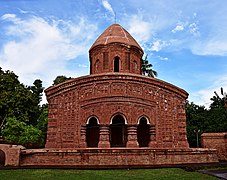
Arranged in a quadrangle, enclosed within a high wall in the Brindaban Chandra Math, are the four temples dedicated to Chaitanyadev (Chaitanya-Nityananda), Brindabanchandra (Radha-Krishna and Jagannath), Ramchandra (Rama, Sita, Lakshmana and Hanuman) and Krishnachandra (Radha-Krishna).[3]
According to David McCutchion,[4] the jor-bangla temple of Chaitanya in the Brindaban Chandra Math is the earliest Bangla-style temple still standing. It was built during the reign of Akbar (1542–1605). The at-chala Brindabanchndra temple was built in 1801. The eka-ratna Ramchandra temple was built in the 17th century. The last temple has a rich terracotta façade.[3]
The Bridaban Chandra Math complex at Guptipara is an ASI listed monument.[5]
Brindaban Chandra’s Math picture gallery
-
 The temple complex
 -
 Chaitanya temple
 -
 Ramchandra temple
 -
 Brindaban Chandra temple
 -
 Krishnachandra temple
 -
 Terracotta in Ramchandra temple
 -
 Terracotta in Ramchandra temple
 -
 Terracotta in Ramchandra temple
 -
 Design around door
 -
 The information board


.jpg)


References
- ^ "37913 Howrah-Katwa Local". Time Table. IndiaRailInfo. Retrieved 31 August 2020.
- ^ "Guptipara, Hooghly – 80 km from Kolkata". Weekend destinations.info. Retrieved 31 August 2020.
- ^ a b "Next weekend you can be at Guptipara". Tithiparna Sengupta. The Telegraph, 26 March 2006. Retrieved 31 August 2020.
- ^ McCutchion, David J., Late Mediaeval Temples of Bengal, first published 1972, reprinted 2017, pages 7, 30, 33, 43, 80. The Asiatic Society, Kolkata, ISBN 978-93-81574-65-2
- ^ "List of Ancient Monuments and Archaeological Sites and Remains of West Bengal - Archaeological Survey of India". Item no. 46. ASI. Retrieved 25 January 2020.

This article about an Indian Hindu place of worship is a stub. You can help Wikipedia by expanding it. |