Hummelsbüttel
Jump to navigation
Jump to search
Hummelsbüttel | |
|---|---|
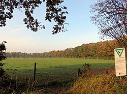
 Streuobstwiese | |
| Coordinates: 53°39′18″N 10°03′00″E / 53.655°N 10.050°E | |
| Country | Germany |
| State | Hamburg |
| City | Hamburg |
| Borough | Hamburg-Wandsbek |
| Area | |
| • Total | 9.2 km2 (3.6 sq mi) |
| Population (2020-12-31)[1] | |
| • Total | 18,538 |
| • Density | 2,000/km2 (5,200/sq mi) |
| Time zone | UTC+01:00 (CET) |
| • Summer (DST) | UTC+02:00 (CEST) |
| Dialling codes | 040 |
| Vehicle registration | HH |
Hummelsbüttel (German pronunciation: [ˌhʊml̩sˈbʏtl̩] ⓘ) is a quarter of Hamburg, Germany in the Wandsbek borough.[2][3][4]

Geography
Hummelsbüttel borders the quarters Poppenbüttel and Wellingsbüttel, as well as the quarters Langenhorn, Fuhlsbüttel, and Ohlsdorf in Hamburg-Nord.
Politics
These are the results of Hummelsbüttel in the Hamburg state election:
| Election | SPD | Greens | CDU | AfD | Left | FDP | Others |
|---|---|---|---|---|---|---|---|
| 2020 | 46,1 % | 17,9 % | 13,3 % | 7,1 % | 5,9 % | 4,9 % | 4,8 % |
| 2015 | 50,5 % | 7,1 % | 18,6 % | 6,7 % | 6,2 % | 8,3 % | 2,6 % |
| 2011 | 50,7 % | 6,7 % | 25,0 % | – | 5,1 % | 8,2 % | 4,3 % |
| 2008 | 33,4 % | 5,6 % | 48,1 % | – | 5,5 % | 5,2 % | 2,2 % |
| 2004 | 29,8 % | 7,8 % | 52,9 % | – | – | 3,9 % | 5,6 % |
| 2001 | 34,8 % | 5,7 % | 30,2 % | – | 0,5 % | 6,1 % | 22,7 % |
| 1997 | 35,2 % | 11,4 % | 33,8 % | – | 0,3 % | 3,6 % | 15,7 % |
| 1993 | 39,4 % | 12,5 % | 27,1 % | – | – | 4,6 % | 16,4 % |
References
- ^ "Bevölkerung in Hamburg am 31.12.2020" (PDF). Statistisches Amt für Hamburg und Schleswig-Holstein. 23 April 2021.
- ^ "Das Ortliche". Das Ortliche. Retrieved 29 January 2019.
- ^ "Katasteramt/Vermessungsamt Hamburg (Kataster)". Katasteramt. Retrieved 29 January 2019.
- ^ "Germany: Hamburg, Boroughs and Quarters". City Population. Retrieved February 14, 2019.
Categories:
- Pages using the Phonos extension
- Articles with short description
- Short description matches Wikidata
- Short description is different from Wikidata
- Pages using infobox settlement with bad settlement type
- Coordinates on Wikidata
- Pages with German IPA
- Pages including recorded pronunciations
- Articles with VIAF identifiers
- Articles with GND identifiers
- Quarters of Hamburg
- Harburg, Hamburg


