Altona-Altstadt
Jump to navigation
Jump to search
You can help expand this article with text translated from the corresponding article in German. (July 2016) Click [show] for important translation instructions.
|
Altona-Altstadt | |
|---|---|
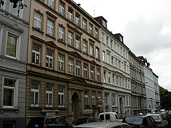
 Virchowstraße | |
| Coordinates: 53°32′56″N 9°56′52″E / 53.54889°N 9.94778°E | |
| Country | Germany |
| State | Hamburg |
| City | Hamburg |
| Borough | Altona |
| Area | |
| • Total | 2.8 km2 (1.1 sq mi) |
| Population (2020-12-31)[1] | |
| • Total | 29,455 |
| • Density | 11,000/km2 (27,000/sq mi) |
| Time zone | UTC+01:00 (CET) |
| • Summer (DST) | UTC+02:00 (CEST) |
| Dialling codes | 040 |
| Vehicle registration | HH |
ⓘ is a quarter in Hamburg (Germany) that belongs to the Altona borough. The quarter's boundaries are congruent with the historic center of what has been the city of Altona until 1937.
History
Altona was founded in 1535 and became a city in 1664. In 1713, it was burned down by Swedish troops. In 1937, it became part of the city of Hamburg.
Geography
Altona-Altstadt is located between the quarters of Ottensen, Altona-Nord, Sternschanze and St. Pauli. In the south, it borders with the Elbe river.
Politics
These are the results of Altona-Altstadt in the Hamburg state election:
| Election | Greens | SPD | Left | CDU | AfD | FDP | Others |
|---|---|---|---|---|---|---|---|
| 2020 | 34,0 % | 25,0 % | 24,2 % | 3,6 % | 2,7 % | 2,1 % | 8,4 % |
| 2015 | 22,3 % | 35,2 % | 23,8 % | 5,0 % | 3,0 % | 3,2 % | 7,5 % |
| 2011 | 17,7 % | 46,6 % | 16,5 % | 7,1 % | – | 2,4 % | 9,7 % |
| 2008 | 17,5 % | 41,1 % | 13,7 % | 21,4 % | – | 2,9 % | 3,4 % |
| 2004 | 26,3 % | 34,4 % | – | 26,5 % | – | 1,7 % | 11,1 % |
References
- ^ "Bevölkerung in Hamburg am 31.12.2020" (PDF). Statistisches Amt für Hamburg und Schleswig-Holstein. 23 April 2021.
Categories:
- Pages using the Phonos extension
- Use dmy dates from May 2022
- Articles needing translation from German Wikipedia
- Articles with short description
- Short description is different from Wikidata
- Pages using infobox settlement with bad settlement type
- Coordinates on Wikidata
- Articles with VIAF identifiers
- Quarters of Hamburg
- Altona, Hamburg
- 1535 establishments in the Holy Roman Empire
- Populated places established in 1535
- Pages using the Kartographer extension


