Csanytelek
Jump to navigation
Jump to search
Csanytelek | |
|---|---|
Village | |
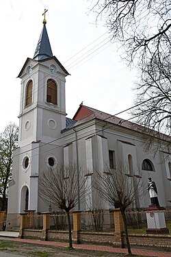
 Roman Catholic church in Csanytelek | |
| Country | |
| County | Csongrád |
| Area | |
| • Total | 34.71 km2 (13.40 sq mi) |
| Population (2015) | |
| • Total | 2,628 |
| • Density | 73.52/km2 (190.4/sq mi) |
| Time zone | UTC+1 (CET) |
| • Summer (DST) | UTC+2 (CEST) |
| Postal code | 6647 |
| Area code | 63 |
Csanytelek is a village in Csongrád-Csanád County, in the Southern Great Plain region of southern Hungary.
Geography
It covers an area of 34.71 km2 (13 sq mi) and has a population of 2628 people (2015).
46°36′22″N 20°06′17″E / 46.60619°N 20.10483°E
Categories:
- Pages using gadget WikiMiniAtlas
- Articles with short description
- Short description is different from Wikidata
- Pages using infobox settlement with no map
- Pages using infobox settlement with no coordinates
- Coordinates on Wikidata
- Articles with VIAF identifiers
- Articles with WorldCat Entities identifiers
- Populated places in Csongrád-Csanád County
- All stub articles
- Csongrád-Csanád County geography stubs


