Óföldeák
Jump to navigation
Jump to search
Óföldeák | |
|---|---|
| Country | |
| County | Csongrád |
| Area | |
| • Total | 35.09 km2 (13.55 sq mi) |
| Population (2002) | |
| • Total | 522 |
| • Density | 15/km2 (40/sq mi) |
| Time zone | UTC+1 (CET) |
| • Summer (DST) | UTC+2 (CEST) |
| Postal code | 6923 |
| Area code | 62 |

Óföldeák is a village in Csongrád county, in the Southern Great Plain region of southern Hungary.
Geography
It covers an area of 35.09 km2 (14 sq mi) and has a population of 569 people (2002).
Képgaléria
-
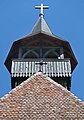
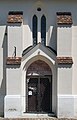
 Római katolikus templom
 -

-
 A templom légifotója
 -
-

-


External links
| Cities with county rights |
|   |
|---|---|---|
| Towns | ||
| Large villages | ||
| Villages |
| |
| Other topics | ||
46°18′N 20°27′E / 46.300°N 20.450°E
| International | |
|---|---|
| National | |
This Csongrád-Csanád County location article is a stub. You can help Wikipedia by expanding it. |
Categories:
- Articles lacking sources from September 2009
- All articles lacking sources
- Articles with short description
- Short description is different from Wikidata
- Pages using infobox settlement with no map
- Pages using infobox settlement with no coordinates
- Coordinates on Wikidata
- Articles with VIAF identifiers
- Articles with WorldCat Entities identifiers
- Articles with J9U identifiers
- Articles with LCCN identifiers
- Populated places in Csongrád-Csanád County
- All stub articles
- Csongrád-Csanád County geography stubs