1964 Manyas earthquake
Jump to navigation
Jump to search
| UTC time | 1964-10-06 14:31:25 |
|---|---|
| ISC event | 863310 |
| USGS-ANSS | ComCat |
| Local date | October 6, 1964 |
| Local time | 16:31:25 |
| Magnitude | 6.8 Mw [1] |
| Depth | 27.4 km (17.0 mi) [1] |
| Epicenter | 40°12′N 28°13′E / 40.2°N 28.21°E [1] |
| Areas affected | Turkey |
| Total damage | $5 million [2] |
| Max. intensity | MMI IX (Violent)[2] |
| Casualties | 19–73 killed, 100–239 injured [2] |
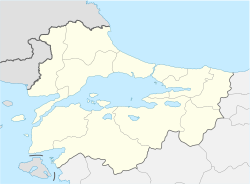
The 1964 Manyas earthquake happened on October 6 on the southern coast of Marmara Sea near the city of Karacabey in Bursa Province, Turkey. The shock had a moment magnitude of 6.8 and a maximum Mercalli intensity of IX (Violent). Around $5 million in damage was caused, with 19–73 killed and 100–239 injured.
See also
References
- ^ a b c ISC (2017), ISC-GEM Global Instrumental Earthquake Catalogue (1900–2013), Version 4.0, International Seismological Centre
- ^ a b c USGS (September 4, 2009), PAGER-CAT Earthquake Catalog, Version 2008_06.1, United States Geological Survey
Further reading
- Kürçer, A.; Özaksoy, V.; Özalp, S.; Güldoğan, Ç. U.; Özdemir, E.; Duman, T. Y. (2017), "The Manyas fault zone (southern Marmara region, NW Turkey): Active tectonics and paleoseismology", Geodinamica Acta, 29 (1): 42–61, Bibcode:2017GeoAc..29...42K, doi:10.1080/09853111.2017.1294013
External links
- The International Seismological Centre has a bibliography and/or authoritative data for this event.
Categories:
- Articles with short description
- Short description is different from Wikidata
- Articles using Mw magnitude scale
- Coordinates on Wikidata
- Earthquakes in Turkey
- 1964 earthquakes
- History of Bursa Province
- Manyas
- 1964 in Turkey
- October 1964 events in Europe
- 1964 disasters in Turkey
- All stub articles
- Asian earthquake stubs

