Årre
Jump to navigation
Jump to search
Årre | |
|---|---|
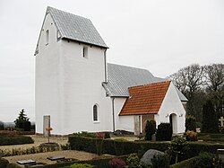
 Årre Church as seen from the southwest. | |
| Coordinates: 55°34′26″N 8°39′56″E / 55.57389°N 8.66556°E | |
| Country | Denmark |
| Region | Southern Denmark (Syddanmark) |
| Municipality | Varde |
| Parish | Årre |
| Population (2024) | |
| • Total | 628 |
| Time zone | UTC+1 (CET) |
| • Summer (DST) | UTC+2 (CEST) |
| Postal Code | 6818 |
Årre is a small town in southwestern Jutland with a population of 628 (1. January 2024),[1] located in Årre Parish. The town is located in Varde Municipality and belongs to the Region of Syddanmark. A little north of Årre town is Årre Kirke, a Romanesque church dating back to the 11th century with a bedoque tower. In the town lies Årre Kro and Årre Skole. The school is a building with space for approx. 200 students and serves as an upper school for Årre, Fåborg and Hjortkær. Årre is located at main route 30 with 16 kilometers to Varde, 18 to Esbjerg and 29 to Grindsted.
References
- ^ BY3: Population 1st January, by urban areas The Mobile Statbank from Statistics Denmark
External links
55°34′N 8°40′E / 55.567°N 8.667°E


