Zavratec, Idrija
Zavratec | |
|---|---|
 Zavratec | |
 Zavratec Location in Slovenia | |
| Coordinates: 45°59′31″N 14°7′54.27″E / 45.99194°N 14.1317417°E | |
| Country | |
| Traditional region | Inner Carniola |
| Statistical region | Gorizia |
| Municipality | Idrija |
| Area | |
| • Total | 3.81 km2 (1.47 sq mi) |
| Elevation | 699.4 m (2,294.6 ft) |
| Population (2002) | |
| • Total | 118 |
| [1] | |
Zavratec (pronounced [zaˈwɾaːtəts]; German: Sauratz[2]) is a village in the hills east of Idrija in the traditional Inner Carniola region of Slovenia.[2]
Geography

Zavratec lies in a small valley surrounded by hills above the valley of Sovra Creek to the north. It includes the hamlets of Zgornji Zavratec and Spodnji Zavratec (literally, 'upper Zavratec' and 'lower Zavratec'). Mravljišče Hill (867 meters or 2,844 feet) rises southwest of the village. The floor of the valley, where the soil is moister, has meadows, and there are tilled fields on the surrounding slopes. Forested land lies mostly to the west, toward the hamlet of Črna in neighboring Dole. In the extreme northeast part of the settlement's territory, above Sovra Creek, is a cave known as Matjaž's Chambers (Slovene: Matjaževe kamre).[3] The cave has six entrances, and archaeologists have found bones of cave bears and other Ice Age animals in it, as well as tools made by Neanderthals (54,000–47,000 YBP) and Homo sapiens (17,000–10,000 YBP).[4]
Name
Zavratec was attested as Czabratza in historical sources in 1500.[5] The etymology of the name is uncertain; it has been suggested that it may be connected to the common noun vrata 'gate', referring to a narrow passage, or to the hydronym Sovra.[6]
History
During the interwar period, Zavratec was part of the Kingdom of Italy, close to the border with Yugoslavia. A dairy operated in the village until 1954, from which cream was sent to Godovič. In 1965 test drilling was carried out near Zavratec in a search for mercury ore.[3]
Church

The parish church in the settlement is dedicated to Saint Ulrich and belongs to the Koper Diocese.[7] It is a Baroque building dating to 1647 with an octagonal chancel walled on three sides, a wide rectangular nave, and a belfry. The interior of the nave and the chancel are ornamented with frescoes dating to 1713. Additional remodeling took place in 1747.[8] The church is surrounded by a cemetery.
Gallery
-
 The hamlet of Spodnji Zavratec
 -
 Chapel shrine in Zavratec
 -
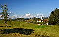 Zavratec With Saint Ulrich's Church


References
- ^ Statistical Office of the Republic of Slovenia Archived November 18, 2008, at the Wayback Machine
- ^ a b Leksikon občin kraljestev in dežel zastopanih v državnem zboru, vol. 6: Kranjsko. 1906. Vienna: C. Kr. Dvorna in Državna Tiskarna, p. 124.
- ^ a b Savnik, Roman (1968). Krajevni leksikon Slovenije, vol. 1. Ljubljana: Državna založba Slovenije. p. 181.
- ^ Idrija Unesco globalni geopark. Obcina Idrija. Tourist information sign in Zavratec.
- ^ "Slovenska historična topografija". Retrieved February 9, 2020.
- ^ "Zavratec". Geopark Idrija. Retrieved February 9, 2020.
- ^ Koper Diocese list of churches Archived March 6, 2009, at the Wayback Machine
- ^ Slovenian Ministry of Culture register of national heritage Archived March 7, 2016, at the Wayback Machine reference number ešd 4135
External links
 Media related to Zavratec at Wikimedia Commons
- Zavratec on Geopedia
| Settlements | Administrative seat: Idrija
|  |
|---|---|---|
| Landmarks | ||
| Notable people | ||
This article about the Municipality of Idrija in Slovenia is a stub. You can help Wikipedia by expanding it. |
- Pages using gadget WikiMiniAtlas
- Webarchive template wayback links
- Articles with short description
- Short description is different from Wikidata
- Coordinates on Wikidata
- Pages with Slovene IPA
- Articles containing German-language text
- Articles containing Slovene-language text
- Commons category link is on Wikidata
- Populated places in the Municipality of Idrija
- All stub articles
- Goriška statistical region geography stubs