Willows, Queensland
| Willows Queensland | |||||||||||||||
|---|---|---|---|---|---|---|---|---|---|---|---|---|---|---|---|
 Train on the Central Western line near Bogantungan, September 1989 | |||||||||||||||
 Willows | |||||||||||||||
| Coordinates | 23°34′26″S 147°24′58″E / 23.5738°S 147.4161°E | ||||||||||||||
| Population | 144 (2016 census)[1] | ||||||||||||||
| • Density | 0.1190/km2 (0.3083/sq mi) | ||||||||||||||
| Postcode(s) | 4702 | ||||||||||||||
| Area | 1,209.8 km2 (467.1 sq mi) | ||||||||||||||
| Time zone | AEST (UTC+10:00) | ||||||||||||||
| Location |
| ||||||||||||||
| LGA(s) | Central Highlands Region | ||||||||||||||
| State electorate(s) | Gregory | ||||||||||||||
| Federal division(s) | |||||||||||||||
| |||||||||||||||
Willows is a rural locality in the Central Highlands Region, Queensland, Australia.[2] In the 2016 census, Willows had a population of 144 people.[1]
Geography
The town of Bogantungan is within the west of the locality (23°39′S 147°17′E / 23.65°S 147.29°E).[3]
The town of Willows Gemfields is the centre of the locality (23°44′S 147°32′E / 23.74°S 147.54°E).[4]
The town of Withersfield is within the east of locality (23°34′44″S 147°33′44″E / 23.5789°S 147.5622°E).[5]
The Central Western railway enters the locality from the east (Anakie Siding/Lochington), passes through the town of Bogantungan, and exits to the west (Alpha). The locality is served by the following stations (from west to east):
- Bogantungan railway station, serving the town of Bogantungan (23°38′55″S 147°17′25″E / 23.6486°S 147.2902°E)[6]
- Kanoloo railway station, now abandoned (23°40′04″S 147°18′52″E / 23.6678°S 147.3144°E)[6]
- Willows railway station (23°39′24″S 147°28′34″E / 23.6568°S 147.4762°E)[6]
- Withersfield railway station, serving the former town of Withersfield, now abandoned (23°34′44″S 147°33′53″E / 23.5790°S 147.5647°E)[6]
History
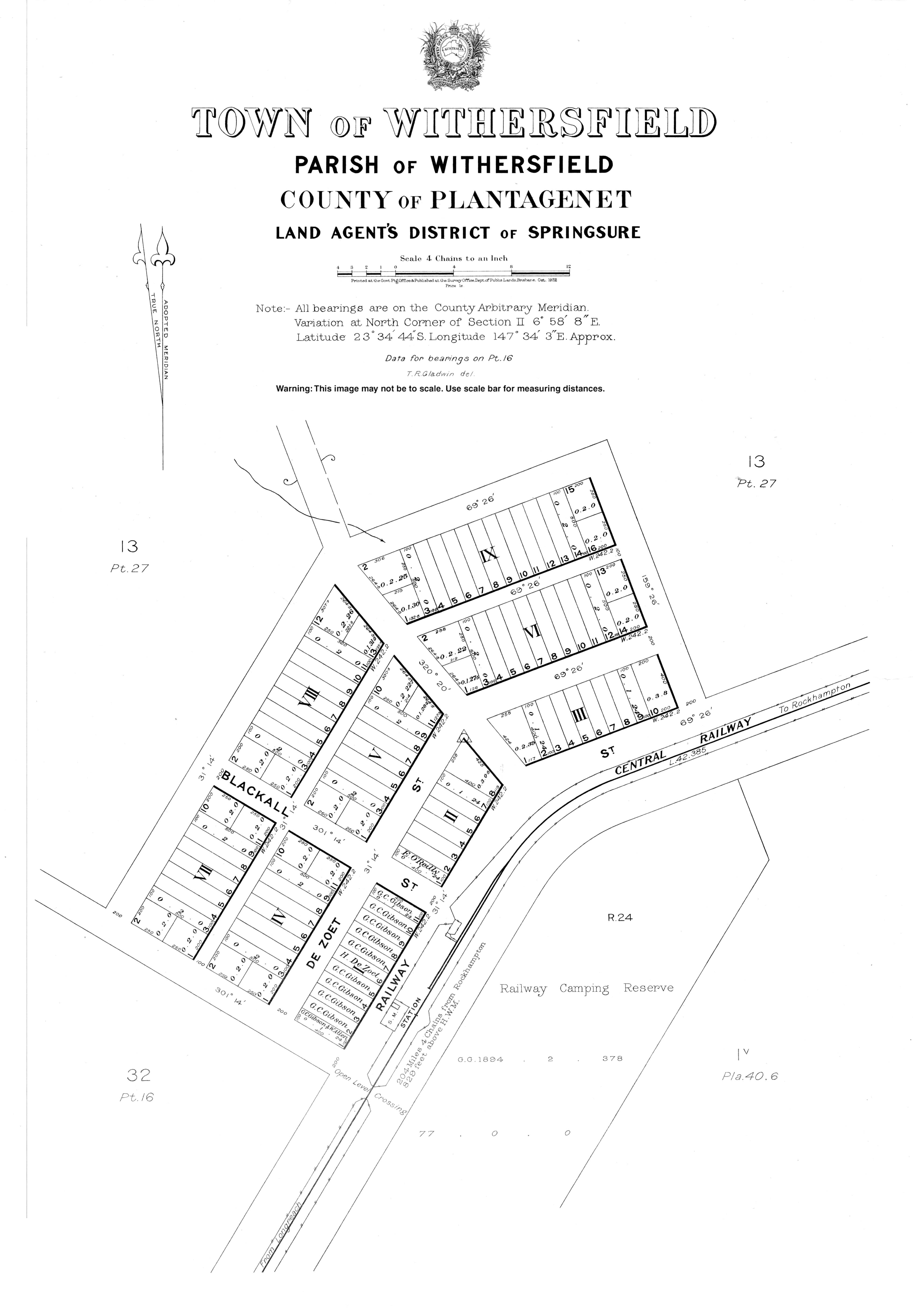
In October 1880, 105 town lots were offered for sale in the Town of Withersfield.[7]
Bogantungan State School opened on 19 March 1883. It closed on 11 August 1972.[8] It was on Jackson Street (23°39′00″S 147°17′15″E / 23.6501°S 147.2875°E).[9][10]
Withersfield Provisional School opened circa 1886 but closed the same year. A new Withersfield State School opened in 1920. On Saturday 9 December 1922, the school burned down after a school picnic and dance evening the previous day.[11][12] The school closed circa 1942.[8] It was located north of the town of Withersfield on a 5-acre-2-rood-11-perch (2.25 ha) site at approx 23°34′33″S 147°33′51″E / 23.5757°S 147.5643°E.[13][14] Nothing remains of the town today.[5][15]
In the 2016 census, Willows had a population of 144 people.[1]
Education
There are no schools in Willows. The nearest government primary schools are Anakie State School in neighbouring Anakie Siding to the east, Lochington State School in neighbouring Lochington to the south, and Alpha State School in neighbouring Alpha to the west.[10] The nearest government secondary schools are Alpha State School (to Year 10) and Emerald State High School (to Year 12) in Emerald to the east. However, these secondary schools may be too distant for daily commuting with distance education and boarding schools as other options.[10]
References
- ^ a b c Australian Bureau of Statistics (27 June 2017). "Willows (SSC)". 2016 Census QuickStats. Retrieved 20 October 2018.
- ^ "Willows – locality in Central Highlands Region (entry 46984)". Queensland Place Names. Queensland Government. Retrieved 25 October 2019.
- ^ "Bogantungan – town (entry 3430)". Queensland Place Names. Queensland Government. Retrieved 24 June 2017.
- ^ "Willlows Gemfields – population centre in the Central Highlands (entry 37569)". Queensland Place Names. Queensland Government. Retrieved 26 October 2019.
- ^ a b "Withersfield – population centre in the Central Highlands Region (entry 37777)". Queensland Place Names. Queensland Government. Retrieved 2 March 2023.
- ^ a b c d "Railway stations and sidings - Queensland". Queensland Open Data. Queensland Government. 2 October 2020. Archived from the original on 5 October 2020. Retrieved 5 October 2020.
- ^ "Advertising". Morning Bulletin. Vol. XXVI, no. 3940. Queensland, Australia. 19 October 1880. p. 3. Retrieved 3 March 2023 – via National Library of Australia.
- ^ a b Queensland Family History Society (2010), Queensland schools past and present (Version 1.01 ed.), Queensland Family History Society, ISBN 978-1-921171-26-0
- ^ "Town of Bogantungan" (Map). Queensland Government. 1971. Archived from the original on 14 January 2020. Retrieved 22 July 2022.
- ^ a b c "Queensland Globe". State of Queensland. Retrieved 22 July 2022.
- ^ "STATE SCHOOL DESTROYED". The Brisbane Courier. No. 20, 249. Queensland, Australia. 14 December 1922. p. 11. Archived from the original on 22 July 2022. Retrieved 22 July 2022 – via National Library of Australia.
- ^ "SCHOOL DESTROYED BY FIRE". Daily Standard. No. 3103. Queensland, Australia. 14 December 1922. p. 4 (SECOND EDITION). Archived from the original on 22 July 2022. Retrieved 22 July 2022 – via National Library of Australia.
- ^ "Anakie" (Map). Queensland Government. 1953. Retrieved 3 March 2023.
- ^ "EDUCATION DEPARTMENT ANNOUNCEMENTS". The Brisbane Courier. No. 20, 220. Queensland, Australia. 10 November 1922. p. 4. Retrieved 3 March 2023 – via National Library of Australia.
- ^ Google (3 March 2023). "Withersfield" (Map). Google Maps. Google. Retrieved 3 March 2023.
External links
- "Town of Withersfield" (Map). Queensland Government. 1922. Archived from the original on 22 July 2022.
- Australian Statistical Geography Standard 2016 ID same as Wikidata
- Use Australian English from August 2019
- All Wikipedia articles written in Australian English
- Use dmy dates from August 2019
- Lists of coordinates
- Geographic coordinate lists
- Articles with Geo
- Articles with short description
- Short description is different from Wikidata
- Coordinates on Wikidata
- Commons category link is on Wikidata
- Central Highlands Region
- Localities in Queensland
- Towns in Queensland