Villazón
Jump to navigation
Jump to search
Villazón
Wiyacha | |
|---|---|
Town | |
.JPG) | |
 Flag  Seal | |
 Villazón Location in Bolivia | |
| Coordinates: 22°05′28″S 65°35′46″W / 22.09111°S 65.59611°W | |
| Country | |
| Department | Potosí |
| Province | Modesto Omiste |
| Elevation | 3,447 m (11,309 ft) |
| Population (2012) | |
| • Total | 37,113 |
| Time zone | UTC-4 (BOT) |
| Website | Official website |
Villazón is a town in southern Bolivia, on the border with Argentina. It sits directly across La Quiaca River from La Quiaca in Argentina. The town is a busy trading hub, with large quantities of goods flowing north.
It is also a heavily used transit hub for tourists passing into Bolivia. A train line connects Villazón with Tupiza, Uyuni and Oruro. Two train services, the Expreso del Sur and slightly cheaper Wara Wara del Sur, each run twice a week. Buses also connect to many destinations.
{{Weather box
| Climate data for La Quiaca/Villazón (1991–2020, extremes 1961–present) | |||||||||||||
|---|---|---|---|---|---|---|---|---|---|---|---|---|---|
| Month | Jan | Feb | Mar | Apr | May | Jun | Jul | Aug | Sep | Oct | Nov | Dec | Year |
| Record high °C (°F) | 27.7 (81.9) |
28.8 (83.8) |
28.0 (82.4) |
25.5 (77.9) |
25.2 (77.4) |
22.4 (72.3) |
21.7 (71.1) |
24.5 (76.1) |
27.2 (81.0) |
27.4 (81.3) |
28.5 (83.3) |
28.6 (83.5) |
28.8 (83.8) |
| Mean daily maximum °C (°F) | 20.6 (69.1) |
20.4 (68.7) |
20.6 (69.1) |
20.3 (68.5) |
17.8 (64.0) |
16.3 (61.3) |
16.1 (61.0) |
18.0 (64.4) |
20.0 (68.0) |
21.7 (71.1) |
22.5 (72.5) |
22.2 (72.0) |
19.7 (67.5) |
| Daily mean °C (°F) | 13.2 (55.8) |
13.0 (55.4) |
12.8 (55.0) |
11.3 (52.3) |
7.3 (45.1) |
4.8 (40.6) |
4.5 (40.1) |
7.0 (44.6) |
10.0 (50.0) |
12.4 (54.3) |
13.4 (56.1) |
13.9 (57.0) |
10.3 (50.5) |
| Mean daily minimum °C (°F) | 7.7 (45.9) |
7.6 (45.7) |
6.6 (43.9) |
3.1 (37.6) |
−2.5 (27.5) |
−5.7 (21.7) |
−6.2 (20.8) |
−4.0 (24.8) |
−0.4 (31.3) |
3.3 (37.9) |
5.5 (41.9) |
7.3 (45.1) |
1.9 (35.4) |
| Record low °C (°F) | 1.7 (35.1) |
−0.1 (31.8) |
−1.0 (30.2) |
−7.9 (17.8) |
−12.6 (9.3) |
−14.6 (5.7) |
−15.2 (4.6) |
−14.8 (5.4) |
−11.2 (11.8) |
−6.3 (20.7) |
−3.5 (25.7) |
0.4 (32.7) |
−15.2 (4.6) |
| Average precipitation mm (inches) | 102.2 (4.02) |
67.9 (2.67) |
48.1 (1.89) |
6.8 (0.27) |
1.1 (0.04) |
0.0 (0.0) |
0.0 (0.0) |
1.2 (0.05) |
3.9 (0.15) |
14.4 (0.57) |
22.2 (0.87) |
63.2 (2.49) |
331.0 (13.03) |
| Average precipitation days (≥ 0.1 mm) | 15.1 | 12.1 | 9.3 | 2.2 | 0.4 | 0.1 | 0.1 | 0.2 | 1.0 | 3.3 | 6.3 | 11.4 | 61.5 |
| Average snowy days | 0.0 | 0.0 | 0.0 | 0.0 | 0.1 | 0.0 | 0.1 | 0.1 | 0.1 | 0.1 | 0.0 | 0.0 | 0.2 |
| Average relative humidity (%) | 62.6 | 63.2 | 60.3 | 46.0 | 32.6 | 27.4 | 25.7 | 26.7 | 32.1 | 42.4 | 48.6 | 55.8 | 43.6 |
| Mean monthly sunshine hours | 263.5 | 228.8 | 269.7 | 288.0 | 297.6 | 285.0 | 297.6 | 303.8 | 291.0 | 306.9 | 303.0 | 275.9 | 3,410.8 |
| Percent possible sunshine | 63.5 | 62.5 | 70.5 | 82.0 | 85.5 | 86.5 | 87.5 | 85.5 | 80.0 | 78.0 | 76.0 | 65.5 | 76.9 |
| Source 1: Servicio Meteorológico Nacional (normals and extremes)[1][2][3] | |||||||||||||
| Source 2: Secretaria de Mineria (sun 1961–1990)[4] | |||||||||||||
Gallery
-
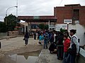 People queueing up to cross the border into Villazón
 -
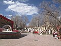 Town square in Villazón
 -
 Una 2pintoresca peatonal de Villazón


Capital: Potosí | ||
| Provinces |  | |
| Municipalities (and seats) |
| |
- ^ "Estadísticas Climatológicas Normales - período 1991-2020" (in Spanish). Servicio Meteorológico Nacional. Retrieved 2 Mar 2023.
- ^ "Estadísticas Climatológicas Normales – período 1991–2020" (PDF) (in Spanish). Servicio Meteorológico Nacional. 2023. Archived from the original on 8 July 2023. Retrieved 4 August 2023.
- ^ "Clima en la Argentina: Guia Climática por La Quiaca Obs". Caracterización: Estadísticas de largo plazo (in Spanish). Servicio Meteorológico Nacional. Archived from the original on 4 September 2017. Retrieved 2 Mar 2023.
- ^ "Datos Meteorológicos Registrados en las Distintas Estación de la Provincia de Jujuy" (in Spanish). Secretaria de Mineria de la Nacion (Argentina). Archived from the original on June 30, 2015. Retrieved March 16, 2015.