Vigala (river)
Jump to navigation
Jump to search
This article needs additional citations for verification. (January 2019) |
| Vigala | |
|---|---|
 The Vigala during summer in Vana-Vigala | |
| Location | |
| Country | Estonia |
| Physical characteristics | |
| Source | |
| • location | Keava Bog |
| Mouth | Kasari River |
• coordinates | 58°44′25″N 24°04′29″E / 58.7403°N 24.0747°E |
| Length | 97 km (60 mi) |
| Basin size | 1,577 km2 (609 sq mi) |
The Vigala is a 96.7 km (60.1 mi)-long river in Rapla County, Estonia. It is a tributary of the Kasari River. Its source is in the Keava Bog. The basin area of the Vigala is 1,577 km2 (609 sq mi).
The largest tributaries of the Vigala are the Velise and Rõue (left tributaries) and the Kodila (a right tributary).
The stone Konuvere Bridge over the Vigala River was the longest stone bridge in Estonia (110 m or 360 ft) when it was opened in 1861.[1]
A rare natural phenomena, the Ice Circle of Vana-Vigala, occurs in the Vigala River.[2]
Gallery
-
 Konuvere railway bridge
 -
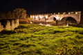 Konuvere stone bridge
 -
 Ice Circle in Vana-Vigala
 -
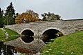 Rapla stone bridge


.jpg)

References
- ^ Memorial stone next to the bridge
- ^ Heleri Kuris, Ats Nukki: Interaktiivne skeem: kuidas tekib Vana-Vigala jõe salapärane jääketas? Delfi, 11. jaanuar 2019
External links
Wikimedia Commons has media related to Vigala River.
Categories:
- Articles with short description
- Short description matches Wikidata
- Articles needing additional references from January 2019
- All articles needing additional references
- Coordinates on Wikidata
- Commons category link is on Wikidata
- Rivers of Estonia
- Landforms of Rapla County
- All stub articles
- Estonia river stubs