Vichy — Charmeil Airport
Jump to navigation
Jump to search
You can help expand this article with text translated from the corresponding article in French. (August 2012) Click [show] for important translation instructions.
|
Vichy – Charmeil Airport Aéroport de Vichy - Charmeil | |||||||||||
|---|---|---|---|---|---|---|---|---|---|---|---|
| Summary | |||||||||||
| Airport type | Public | ||||||||||
| Operator | Mairie de Vichy | ||||||||||
| Serves | Vichy, France | ||||||||||
| Location | Charmeil | ||||||||||
| Elevation AMSL | 817 ft / 249 m | ||||||||||
| Coordinates | 46°10′18″N 003°24′15″E / 46.17167°N 3.40417°E | ||||||||||
| Map | |||||||||||
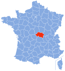
Location of airport in Allier department | |||||||||||
| Runways | |||||||||||
| |||||||||||
Vichy – Charmeil Airport (French: Aéroport de Vichy - Charmeil) (IATA: VHY, ICAO: LFLV) is an airport located in Charmeil, 5 km (3 NM) north-northwest of Vichy,[1] both communes in the Allier department of the Auvergne region in central France.
Facilities
The airport resides at an elevation of 817 feet (249 m) above mean sea level. It has one runway designated 01/19 with an asphalt surface measuring 2,200 by 45 metres (7,218 ft × 148 ft).[1]
References
- ^ a b c LFLV – VICHY CHARMEIL. AIP from French Service d'information aéronautique, effective 13 June 2024.

