Van Buren–St. Leonard Border Crossing
Jump to navigation
Jump to search
| Van Buren–St. Leonard Border Crossing | |
|---|---|
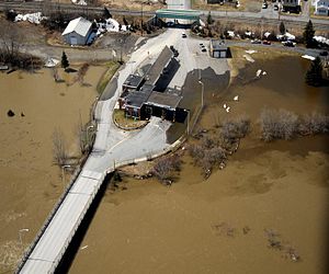
 The US Border Inspection Station at Van Buren, ME taken during the flood of May 2008 | |
| Location | |
| Country | United States; Canada |
| Location |
|
| Coordinates | 47°09′35″N 67°55′51″W / 47.159643°N 67.930827°W |
| Details | |
| Opened | 1847 |
| US Phone | (207) 868-3391 |
| Hours | Open 24 hours |
| Website http://www.cbp.gov/contact/ports/van-buren | |
The Van Buren–St. Leonard Border Crossing is located at the Saint Leonard – Van Buren Bridge that connects the town of Van Buren, Maine with St. Leonard, New Brunswick on the Canada–United States border. During the 19th century, hand-pulled ferry service connected these two cities. In 2008, a flood of the Saint John River severely damaged the Van Buren border station.[1] A new facility was completed in 2013.

See also
References
- ^ "Construction of new Van Buren border station to detour traffic for 3 days". Bangor Daily News. September 28, 2012. Retrieved 2014-07-21.
Categories:
- Pages using gadget WikiMiniAtlas
- Articles with short description
- Short description with empty Wikidata description
- Coordinates on Wikidata
- Canada–United States border crossings
- Madawaska County, New Brunswick
- Van Buren, Maine
- 1847 establishments in Maine
- 1847 establishments in New Brunswick
- All stub articles
- New Brunswick geography stubs
- Maine geography stubs