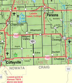
Valeda, Kansas
Jump to navigation
Jump to search
Valeda, Kansas | |
|---|---|
 | |
| Coordinates: 37°02′50″N 95°26′51″W / 37.04722°N 95.44750°W[1] | |
| Country | United States |
| State | Kansas |
| County | Labette |
| Founded | 1880s |
| Platted | 1886 |
| Elevation | 860 ft (260 m) |
| Time zone | UTC-6 (CST) |
| • Summer (DST) | UTC-5 (CDT) |
| Area code | 620 |
| FIPS code | 20-72700 [1] |
| GNIS ID | 469169 [1] |
Valeda is an unincorporated community in Labette County, Kansas, United States.[1]
History
Valeda was platted in 1886.[2]
References
- ^ a b c d e "Valeda, Kansas", Geographic Names Information System, United States Geological Survey, United States Department of the Interior
- ^ Blackmar, Frank Wilson (1912). Kansas: A Cyclopedia of State History, Volume 2. Standard Publishing Company. pp. 839.
Further reading
External links
Categories:
- Pages using gadget WikiMiniAtlas
- Use mdy dates from July 2023
- Articles with short description
- Short description is different from Wikidata
- Coordinates on Wikidata
- Pages using infobox settlement with image map1 but not image map
- Unincorporated communities in Labette County, Kansas
- Unincorporated communities in Kansas
- All stub articles
- Southeast Kansas geography stubs


