User talk:Goran tek-en/talk/2016
Happy Holidays and a little request
Hello Goran tek-en,
Happy Holidays to you. I wanted to make a little request. This map: [1] has the word "Kingdom of Georgia" very big and the "Principality of Armenia" very small. Since Zakarid Armenia is more relevant to the Principality of Armenia, can we have the "Principality of Armenia" font enlarged and the Kingdom of Georgia text size reduced? If you can do this that will be great. There's not rush, I know it's holiday season. See you! Étienne Dolet (talk) 01:38, 25 December 2015 (UTC)
- @EtienneDolet:Have a look here and see if this is OK? --Goran tek-en (talk) 18:44, 29 December 2015 (UTC)
- Yes, much better. Thank you. Should I upload that file myself onto Commons? Étienne Dolet (talk) 18:49, 29 December 2015 (UTC)
- I have uploaded the new version. --Goran tek-en (talk) 19:41, 29 December 2015 (UTC)
- Yes, much better. Thank you. Should I upload that file myself onto Commons? Étienne Dolet (talk) 18:49, 29 December 2015 (UTC)
Please take a look at my request at Map Workshop
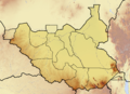
Hello Goran tek-en, I need your help. Can you please take a look at my request Wikipedia:Graphics Lab/Map workshop#Please create a map highlighting Greater Pibor Administrative Area in old Jonglei State? The request hasn't even be answered by anyone for a week. I request you to please take a look at it. Thank you very much. DinoBambinoNFS (talk) 17:05, 22 August 2016 (UTC)
- Hi DinoBambinoNFS, well a week is not that long here, really.
- Also I can see that you don't have a user page anywhere, you don't need to have one but often it's nice to know a bit more about who you are working with and what they have done earlier.
- I have looked at your two reference links and I can use that as a base. My question is if we are allowed to use their maps?
- I have sent questions to them explaining what we want to do and if it's OK regarding their copyright. I will wait for there answers and then we can continue if we can use them. So if you haven't heard from me for some time just get back to me, thanks.--Goran tek-en (talk) 17:39, 22 August 2016 (UTC)
- 1 week isn't a normal time for me. I like to focus on one thing at a time. This request has been on my mind for months, even before I started editing with a handle. I haven't had time to even request since yet because I've been very busy with other edits. I've had to update the information about cities of South Sudan, their counties and states all by myself. There has never been a map for Greater Pibor and other users have not cared when I personally asked them to create one. DinoBambinoNFS (talk) 18:34, 22 August 2016 (UTC)
- We are all busy with other stuff and we are all doing this on our free time so please have some patience and understanding.
- You didn't answer my question or other thoughts regarding this request, please do so. --Goran tek-en (talk) 10:39, 23 August 2016 (UTC)
The map actually only show 2 counties of older Jonglei state as forming Greater Pibor. If you see the map closely, you can figure that out. I doubt you can't use it for reference since it is basically using the boundaries of the 2 counties to show the region. DinoBambinoNFS (talk) 11:09, 23 August 2016 (UTC)
- What I can say that the sources are quite reliable. The website is spent by researchers who have spent years researching and mapping in East Africa. The developer of the website has had his research funded by National Geographic and University of Miami, see See about us section of the website. DinoBambinoNFS (talk) 11:09, 23 August 2016 (UTC)
- I also think they are reliable but the question is if they allow us to use the map, if their copyright allows it? But as I said before I have sent emails asking, we will just wait and see for some time. --Goran tek-en (talk) 12:01, 23 August 2016 (UTC)
I tried to search but couldn't find any copyright. I thought copyrights only prevented sharing, now we can't use them as a reference to draw some lines on a map? DinoBambinoNFS (talk) 12:09, 23 August 2016 (UTC)
- This is always a problematic issue, look here. For instance I can't use a print screen from google maps to create a new map but I can use a screen print from open street map if I give them credit. Of course I can pretend that I just "had this information" without looking at that map but then on the other hand I wan't other people to respect the copyright licenses I use, so... This page also give you some info on this subject, it's not easy or always really clear.
- I have got one answer but it didn't give me anything so I wait for map east africa. --Goran tek-en (talk) 17:36, 23 August 2016 (UTC)
I've requested them to give permission to use it. Let's see if they reply back. DinoBambinoNFS (talk) 20:22, 23 August 2016 (UTC)
![]() Done
Done
Please redraw South Sudan topographic map showing the new states
Hello. I'm sorry for making another request but can you redraw the topographic map of South Sudan showing boundaries of the new states? The author of the original map is no longer active and his map is based on old states. A new map is needed for showing the topography in relation to the new states. I'm linking his topographic map and a location map showing the boundaries of the new states:
-
 The original topographic map
 -
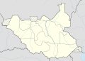 Location map showing boundaries of new states


![[1]](https://en.wikipedia.org/wiki/File:Principality_of_Armenia-Zakarid_Armenia.svg)
I don't think you'll have any problems with this since the reference map is a Wikipedia map that can be remixed and adapted. I request you to please draw it. Thank you. DinoBambinoNFS (talk) 20:31, 23 August 2016 (UTC)
- Yes I can do that but I would like you to make a request on the graphic workshop/map so that other people also can see it and give input if needed. Ping me in the request and I will take it.
- The topographic map is a png image(bitmap) but the location map is a svg image (vector) and svg is prefererad as it it's easier to edit and can be used in any size without resolution lost~so I will create the new one as a svg, thanks. --Goran tek-en (talk) 10:54, 25 August 2016 (UTC)
I've made a request on Wikipedia:Graphics Lab/Map workshop#Please redraw South Sudan topographic map showing the new states. The Workshop does not seem to be very active so I don't know if anyone will give any input. But we'll see, I hope everyone agrees with redrawing it. DinoBambinoNFS (talk) 15:15, 25 August 2016 (UTC)
Hello again Goran,can you please upload the redrawn map quickly? I don't like making this comment but it has been 4 days since you showed the draft and about 2 weeks since I made the request. The sooner the new map is uploaded, the better. DinoBambinoNFS (talk) 07:08, 5 September 2016 (UTC)
- But you did make the comment. Do I have to explain how my life is for you, or is that something I can keep to myself?
- I try to do this voluntary work here as good and as quick as I can, sometimes other parts of ones life has priority of this here. --Goran tek-en (talk) 15:04, 5 September 2016 (UTC)
- I know you might be busy and would have some other priorities. The maps have been outdated for months and I myself didn't find much free time until now to have them updated. I wanted to update them as quickly as possible because as I already said they are outdated. If I knew how to redraw them, I would do it myself instead of disturbing others. Unfortunately I can't, that's why I asked others. Had they not been so much outdated, I wouldn't have commented again and again. Sorry if I troubled you, please know I appreciate you taking the time to answer and resolve mine and other people's requests. DinoBambinoNFS (talk) 05:26, 6 September 2016 (UTC)
![]() Done
Done