Twijzelerheide
Jump to navigation
Jump to search
Twijzelerheide
Twizelerheide | |
|---|---|
Village | |
 Clock Tower | |
 Flag  Coat of arms | |
 Location in Achtkarspelen municipality | |
 Twijzelerheide Location in the Netherlands | |
| Coordinates: 53°15′N 6°03′E / 53.250°N 6.050°E | |
| Country | |
| Province | |
| Municipality | |
| Area | |
| • Total | 6.32 km2 (2.44 sq mi) |
| Elevation | 1 m (3 ft) |
| Population (2021)[1] | |
| • Total | 1,775 |
| • Density | 280/km2 (730/sq mi) |
| Postal code | 9287[1] |
| Dialing code | 0512 |
| Website | Official |
Twijzelerheide (West Frisian: Twizelerheide) is a village in Achtkarspelen in the province of Friesland, the Netherlands. It had a population of around 1800 in 2017.[3]
A dialect of Wood Frisian, Westereendersk dialect, is spoken in this village.
The village was first mentioned in 1718 as heyde, and means "heath near Twijzel".[4] Twijzelerheide developed in the 19th century as a heath cultivation project. The Dutch Reformed Church dates from 1878.[5] Twijzelerheide and Zwagerbosch have grown together, and nowadays share resources and can be considered a twin village.[6]
Gallery
-
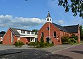 Dutch Reformed Church
 -
 Little house
 -
 Flowers in the garden


References
- ^ a b c "Kerncijfers wijken en buurten 2021". Central Bureau of Statistics. Retrieved 29 March 2022.
two entries
- ^ "Postcodetool for 9287HA". Actueel Hoogtebestand Nederland (in Dutch). Het Waterschapshuis. Retrieved 29 March 2022.
- ^ Villages - Achtkarspelen (in Dutch)
- ^ "Twijzelerheide - (geografische naam)". Etymologiebank.nl (in Dutch). Retrieved 29 March 2022.
- ^ Ronald Stenvert & Sabine Broekhoven (2000). "Twijzelerheide" (in Dutch). Zwolle: Waanders. ISBN 90 400 9476 4. Retrieved 29 March 2022.
- ^ "Twijzelerheid". Plaatsengids (in Dutch). Retrieved 29 March 2022.
External links
![]() Media related to Twijzelerheide at Wikimedia Commons
Media related to Twijzelerheide at Wikimedia Commons
- Official site (in Dutch)

This Friesland location article is a stub. You can help Wikipedia by expanding it. |
Categories:
- CS1 Dutch-language sources (nl)
- Articles with Dutch-language sources (nl)
- Articles with short description
- Short description is different from Wikidata
- Coordinates on Wikidata
- Articles containing West Frisian-language text
- Commons category link from Wikidata
- Achtkarspelen
- Populated places in Friesland
- All stub articles
- Friesland geography stubs