Tolgus Mount
| Tolgus Mount | |
|---|---|
 The Murdoch Flyer | |
 Tolgus Mount Location within Cornwall | |
| OS grid reference | SW684428 |
| Civil parish |
|
| Unitary authority | |
| Ceremonial county | |
| Region | |
| Country | England |
| Sovereign state | United Kingdom |
| Post town | REDRUTH |
| Postcode district | TR15 |
| Dialling code | 01209 |
| Police | Devon and Cornwall |
| Fire | Cornwall |
| Ambulance | South Western |
| UK Parliament | |
Tolgus Mount (also Tolgus or Tolgoose[1]) is a village, valley, and district in the parish of Redruth in Cornwall, England, United Kingdom. It is located to the northwest of town of Redruth across the A30 road and falls within the Redruth North ward on Cornwall Council.[2] Historically there were several mines in the area, mining tin and copper.
History
Historically Tolgus was known for its tin mining and there were several mines in the area including West, East and South Tolgus.[3] The area produced several hundred tons of black tin between 1847 and 1869 and 57 tons between 1847 and 1863 in the East Tolgus Mine and many more tons of copper ore.[4] The South Tolgus Mine was 157 fathoms deep, the West Tolgus Mine 135 fathoms deep and the Great South Tolgus 80 fathoms deep as reported in 1922.[5] In 1884 the manor of Tolgus reportedly consisted of 212 tenements and 1006 acres.[6]
Geography

Tolgus forms a valley to the northwest of Redruth.[7] It lies in the parish of Redruth to the northwest across the A30 road and is spread over an area which is known as Tolgus with parts such as West Tolgus, South Tolgus, East Tolgus.[4][8][9] Paynter's Lane End lies to the northwest and the hamlet of North Country to the northeast. There is a stream running in the area which runs under the A30.
Notable landmarks
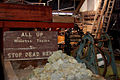
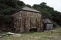
Next to Cornwall Gold lies the old mill at Tolgus, although this northern part of the village is closest to North Country and often considered part of it. Tolgus Tin, covering 20 acres, is now a working museum, showcasing the old mining machinery.[10] The land surrounding this mill forms part of West Cornwall Bryophytes Site of Special Scientific Interest.[11]
There is a candle factory at Tolgus Mount "where the path leads towards the Old Portreath Road".[12] There is a house called Tolgus House in the village, occupied by Edmund Percival James in the 1960s.[13][14] Other features in the area include Brunton's arsenic calciner, Tehidy Holiday Park, Tricky's Hotel,[15] Tolgus Cottage and Dalgover House. There is a full-scale replica of a steam carriage which William Murdoch built as a working model in 1784 called "The Murdoch Flyer" situated in the centre of Tolgus roundabout on the other side of the A30 on the outskirts of Redruth. The road from there leads across the A30 to Tolgus.[16]
-
 Tolgus Mill
 -
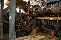 Tolgus mill water hammer
 -
 Donkeys near Great South Tolgus Mine
 -
 Brunton's arsenic calciner


References
- ^ Polsue, Joseph (1872). A complete parochial history of the county of Cornwall: compiled from the best authorities & corrected and improved from actual survey ; illustrated. W. Lake. Retrieved 19 January 2012.
- ^ "Cornwall Council Interactive Map". Cornwall Council. Retrieved 8 November 2020.
- ^ Newcomen Society (Great Britain) (1983). Industrial archaeology: the journal of the history of industry and technology. Lambarde Press. p. 94. Retrieved 19 January 2012.
- ^ a b Collins, Joseph Henry (1912). Observations on the west of England mining region: being an account of the mineral deposits and economic geology of the region, and forming vol. XIV of the transactions of the Royal Geological Society of Cornwall. Author. Retrieved 19 January 2012.
- ^ Geological Survey of Great Britain (1922). Special reports on the mineral resources of Great Britain ... H.M. Stationery Office. p. 157. Retrieved 19 January 2012.
- ^ Bond, Chris (2007). An Index to the Historical Place Names of Cornwall – Volume 2. Cornovia Press. p. 281. ISBN 978-0-9522064-3-9. Retrieved 19 January 2012.
- ^ Great Britain. Parliament. House of Commons (1879). Reports from commissioners. House of Commons. p. 257. Retrieved 19 January 2012.
- ^ The Journal of European economic history. Banco di Roma. 2000. Retrieved 19 January 2012.
- ^ The Mining and smelting magazine. The Office. 1862. p. 318. Retrieved 19 January 2012.
- ^ Western miner. 1975. p. 37. Retrieved 19 January 2012.
- ^ "West Cornwall Bryophytes" (PDF). Natural England. 1999. Retrieved 31 January 2012.
- ^ Michell, Frank (1978). Annals of an ancient Cornish town: being notes on the history of Redruth. Dyllansow Truran. ISBN 9780907566854. Retrieved 19 January 2012.
- ^ The electrical review. Electrical Review, Ltd. 1955. p. 146. Retrieved 19 January 2012.
- ^ "Tricky's, Tolgus Mount, Redruth". Miller Commercial. Retrieved 19 January 2012.
- ^ Ordnance Survey: Landranger map sheet 203 Land's End ISBN 978-0-319-23148-7