Tōshijima
Jump to navigation
Jump to search
Native name: (答志島) | |
|---|---|
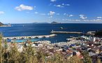
 Tōshijima from Sugashima | |
 | |
| Geography | |
| Location | Mie Prefecture |
| Coordinates | 34°31′13″N 136°52′39.4″E / 34.52028°N 136.877611°E |
| Area | 6.98 km2 (2.69 sq mi) |
| Coastline | 26,300 m (86300 ft) |
| Highest elevation | 167.2 m (548.6 ft) |
| Administration | |
Japan | |
| Demographics | |
| Population | 2,981 (2000) |
| Ethnic groups | Japanese |
Tōshijima (答志島) is an inhabited island located in Ise Bay off the east coast of central Honshu, Japan. It is administered as part of the city of Toba in Mie Prefecture. It is the largest of the outlying islands of Toba.
The name of Tōshijima appears in early documents, such as the Man'yōshū and Wamyō Ruijushō, and was a base for pirates led by Kuki Yoshitaka in the Sengoku period.
During the Meiji period, the island was made part of Tōshi District (答志郡), which became part of Shima District from 1896. On November 1, 1954, the island became part of the city of Toba. The economy of the island is based on commercial fishing, aquaculture and tourism.
-
 Port of Momotori
 -
 Port of Wagu
 -
 Port of Tōshi


References
- Saishin-Nihon-chizu - Atlas of Japan, Imidas Shueisha, Tokyo 1990
External links
Wikimedia Commons has media related to Tōshijima.
| International | |
|---|---|
| National | |
This Mie Prefecture location article is a stub. You can help Wikipedia by expanding it. |
Categories:
- Pages using gadget WikiMiniAtlas
- Articles containing Japanese-language text
- Infobox mapframe without OSM relation ID on Wikidata
- Coordinates on Wikidata
- Commons category link is on Wikidata
- Articles with VIAF identifiers
- Articles with NDL identifiers
- Islands of Mie Prefecture
- All stub articles
- Mie geography stubs
- Pages using the Kartographer extension