Sveta Ema
Jump to navigation
Jump to search
Sveta Ema | |
|---|---|
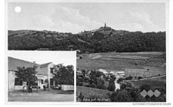
 Postcard of Sveta Ema | |
| Coordinates: 46°10′49.36″N 15°36′38.16″E / 46.1803778°N 15.6106000°E | |
| Country | |
| Traditional region | Styria |
| Statistical region | Savinja |
| Municipality | Podčetrtek |
| Area | |
| • Total | 1.38 km2 (0.53 sq mi) |
| Elevation | 316 m (1,037 ft) |
| Population (2002) | |
| • Total | 178 |
| [1] | |
Sveta Ema (pronounced [ˈsʋeːta ˈeːma]) is a settlement in the Municipality of Podčetrtek in eastern Slovenia. The area around Podčetrtek is part of the traditional region of Styria. It is now included in the Savinja Statistical Region.[2]
The settlement gets its name from the parish church, dedicated to Saint Hemma. It belongs to the Roman Catholic Diocese of Celje. It was built in 1717.[3]
References
External links

