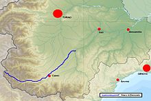
Stura di Demonte
Jump to navigation
Jump to search
| Stura di Demonte | |
|---|---|
 The Stura during its Alpine stage (at Pietraporzio) | |
 Location within southern Piedmont | |
| Location | |
| Country | Italy (Piedmont: Province of Cuneo) |
| Physical characteristics | |
| Source | |
| • location | Lago della Maddalena, close to the Maddalena Pass |
| • elevation | 1,990 m (6,530 ft)[1] |
| Mouth | |
• location | Tanaro, near Cherasco |
• coordinates | 44°39′04″N 7°52′52″E / 44.6512°N 7.8812°E |
| Length | 115 km (71 mi) |
| Basin size | 1,579 square kilometres (610 sq mi) |
| Discharge | |
| • average | 47 cubic metres per second (1,700 cu ft/s) |
| Basin features | |
| Progression | Tanaro→ Po→ Adriatic Sea |
Stura di Demonte (Latin: Stura) is a 115-kilometre (71 mi) long river in northwestern Italy (Piedmont).
Geography
The river is a tributary to the river Tanaro, which is a tributary of the river Po. Its source is in the Alps, near the border with France. It flows through Demonte and Cuneo before joining the Tanaro just east of Cherasco.
See also
Notes
- ^ Source elevation taken from Comuni della Valle Stura - Comunità Montana Valle Stura di Demonte Archived 2007-08-09 at the Wayback Machine
![]() Media related to Stura di Demonte at Wikimedia Commons
Media related to Stura di Demonte at Wikimedia Commons
Categories:
- Webarchive template wayback links
- Articles with short description
- Short description matches Wikidata
- Coordinates on Wikidata
- Tributaries of the Tanaro
- Articles containing Latin-language text
- Commons category link from Wikidata
- Articles with VIAF identifiers
- Articles with BNF identifiers
- Articles with BNFdata identifiers
- Articles with J9U identifiers
- Articles with LCCN identifiers
- Rivers of the Province of Cuneo
- Rivers of Italy
- Rivers of the Alps
- All stub articles
- Piedmont geography stubs
- Italy river stubs