Strait of Bonifacio
| Strait of Bonifacio | |
|---|---|
.JPG) Strait of Bonifacio | |
 Strait of Bonifacio  Strait of Bonifacio  Strait of Bonifacio | |
| Location | Mediterranean Sea |
| Coordinates | 41°18′43″N 9°12′46″E / 41.31194°N 9.21278°E |
| Type | Strait |
| Basin countries | France Italy |
| Min. width | 11 kilometres (6.8 mi) |
| Max. depth | 100 metres (330 ft) |
| Settlements | Bonifacio |
The Strait of Bonifacio (French: Bouches de Bonifacio; Italian: Bocche di Bonifacio; Corsican: Bucchi di Bunifaziu; Gallurese: Bocchi di Bunifaciu; Sardinian: Buccas de Bonifatziu; Ligurian: Bocche de Bunifazziu; Latin: Fretum Gallicum, Fretum Taphros) is the strait between Corsica and Sardinia, named after the Corsican town Bonifacio. It is 11 km (6.8 mi) wide[1] and divides the Tyrrhenian Sea from the western Mediterranean Sea. The strait is notorious among sailors for its weather, currents, shoals, and other obstacles. The strait, while relatively narrow, has no fixed link and relies on ferry services.
The most famous disaster in the Strait of Bonifacio was that of the French frigate Sémillante on February 15, 1855. Sémillante had left the port of Toulon the day before on her way into the Black Sea to supply the Crimean War with troops. A storm caused her to hit a reef; the ship sank and none of the 750 soldiers on board survived.
After a tanker disaster in 1993, the passage through the Strait of Bonifacio has been prohibited for French and Italian flag ships with dangerous goods. Passage for ships with dangerous goods sailing under other flags is strongly discouraged and subject to mandatory piloting.[2][3]
Its maximum depth is 100 metres (330 ft).[4]
Gallery
- Strait of Bonifacio
-
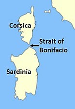 Location of the Strait.
 -
 The Strait as seen from Santa Teresa di Gallura in Sardinia; Corsica is in the background.
 -
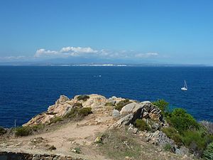
 The Strait as seen from the northernmost tip of Sardinia; the southern coast of Corsica is barely visible.
 -
 The Strait as seen from the Corsican coast.
 -
 The Strait as seen from the air.


See also
References
- ^ "European Space Agency Observing the Earth". web page. European Space Agency. Retrieved 4 October 2011.
- ^ "The Strait of Bonifacio: a Particularly Sensitive Sea Area (PSSA)". Retrieved 18 June 2013.
- ^ "IMO Resolution A.666(18) Navigation in the Strait of Bonifacio" (PDF). Retrieved 18 June 2013.
- ^ "International Maritime Organization Marine Environment Protection Committee 61st Session, Agenda Item 9 Annex, page 1" (PDF). International Maritime Organization. Retrieved 4 October 2011.
External links
| Administrative divisions |  | |
|---|---|---|
| History | ||
| Politics | ||
| Culture | ||
| Languages | ||
This Corsica geographical article is a stub. You can help Wikipedia by expanding it. |
This Sardinia location article is a stub. You can help Wikipedia by expanding it. |
- Articles with short description
- Short description is different from Wikidata
- Pages using infobox body of water with auto short description
- Articles containing Corsican-language text
- Articles containing Gallurese-language text
- Articles containing Sardinian-language text
- Coordinates on Wikidata
- Articles using infobox body of water without alt
- Articles using infobox body of water without pushpin map alt
- Articles using infobox body of water without image bathymetry
- Articles containing French-language text
- Articles containing Italian-language text
- Articles containing Ligurian-language text
- Articles containing Latin-language text
- Commons category link is on Wikidata
- Articles with VIAF identifiers
- Straits of the Mediterranean Sea
- International straits
- Straits of Italy
- Straits of Metropolitan France
- Landforms of Corsica
- Landforms of Sardinia
- Landforms of the Tyrrhenian Sea
- France–Italy border
- All stub articles
- Corsica geography stubs
- Sardinia geography stubs