Snake River (Nome, Alaska)
Jump to navigation
Jump to search
| Snake River | |
|---|---|
 Mouth of the Snake River at Nome | |
 Location of the mouth of the Snake River in Alaska | |
| Location | |
| Country | United States |
| State | Alaska |
| District | Nome Census Area |
| Physical characteristics | |
| Source | Seward Peninsula |
| • location | Confluence of Goldbottom Creek and North Fork Snake River |
| • coordinates | 64°42′05″N 165°24′25″W / 64.70139°N 165.40694°W[1] |
| • elevation | 193 ft (59 m)[2] |
| Mouth | Norton Sound, Bering Sea |
• location | Nome |
• coordinates | 64°29′55″N 165°24′47″W / 64.49861°N 165.41306°W[1] |
• elevation | 13 ft (4.0 m)[1] |
| Length | 20 mi (32 km)[1] |
Snake River is a waterway on the Seward Peninsula in the U.S. state of Alaska. Flowing southerly, it discharges into Norton Sound, Bering Sea, at Nome, with its mouth lying between the city's downtown area and its main airport. The river is 20 miles (32 km) long.[1]
Gallery
-
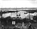 Boats and tents at the mouth of the Snake River in Nome, ca. 1900
 -
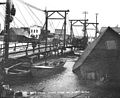 Snake River Bridge and post-storm destruction in Nome (October 1902) by Eric A. Hegg
 -
 A small boat navigates the Snake River in Nome September 29, 1909
.jpeg)
.jpeg)
.jpeg)
See also
References
- ^ a b c d e "Snake River". Geographic Names Information System. United States Geological Survey. March 31, 1981. Retrieved September 22, 2013.
- ^ Derived by entering source coordinates in Google Earth.
External links
 Media related to Snake River (Nome, Alaska) at Wikimedia Commons
- Alaska Fishing and Hunting Guides Directory
- Inactive Snake Hydrological Station
- Photos
| International | |
|---|---|
| Other | |
This article about a location in the Nome Census Area, Alaska is a stub. You can help Wikipedia by expanding it. |
Categories:
- Pages using gadget WikiMiniAtlas
- Articles with short description
- Short description is different from Wikidata
- Coordinates on Wikidata
- IMDb title ID not in Wikidata
- Commons category link from Wikidata
- Articles with VIAF identifiers
- Articles with SUDOC identifiers
- Rivers of Nome Census Area, Alaska
- Rivers of the Seward Peninsula
- Rivers of Alaska
- Rivers of Unorganized Borough, Alaska
- All stub articles
- Nome Census Area, Alaska geography stubs
- Alaska river stubs