Seaforth Island
| Scottish Gaelic name | Eilean Shìophoirt or Mulag |
|---|---|
| Old Norse name | Múli |
| Meaning of name | Norse for 'craggy ridge between fjords'; Gaelic for "island of Seaforth" |
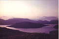
 Loch Seaforth and Eilean Shìophoirt from the north with Clisham beyond | |
| Location | |
 Seaforth Island Seaforth Island shown within the Outer Hebrides | |
| OS grid reference | NB207111 |
| Coordinates | 58°00′00″N 6°43′45″W / 58.00°N 06.7292°W |
| Physical geography | |
| Island group | Outer Hebrides |
| Area | 273 hectares (1.05 sq mi) |
| Area rank | 92 [1] |
| Highest elevation | 217 metres (712 ft) |
| Administration | |
| Sovereign state | United Kingdom |
| Country | Scotland |
| Council area | Outer Hebrides |
| Demographics | |
| Population | 0 |
| References | [2][3][4] |
| Seaforth Island | |
|---|---|
| Highest point | |
| Elevation | 217 m (712 ft) |
| Prominence | 217 m (712 ft) |
| Listing | Marilyn |
| Geography | |
| Location | Loch Seaforth between Harris and Lewis, Scotland |
| OS grid | NB207111 |
| Topo map | OS Landrangers 13, 14 |
Seaforth Island (Scottish Gaelic: Eilean Shìphoirt/Shìophoirt or Mulag) is an uninhabited island in the Outer Hebrides of Scotland. Unlike many other islands of the Outer Hebrides which are mainly surrounded by open sea, Seaforth Island lies in a narrow fjord-like sea loch named Loch Seaforth, 8 kilometres (5.0 mi) from the open waters of The Minch.
The island has poor soil which only supports rough grazing.
History
There are no census records indicating inhabitation in the recent past, although the loch area was the subject of border disputes in the 19th century. In 1851 these were resolved by the unusual decision to allocate the whole of Seaforth Island to both counties, Ross-shire and Inverness-shire, which at the time controlled Lewis and Harris respectively.[4] This situation continued until the 1975 county reorganisation.
Gallery
-
 The Island from Lewis and Harris
 -
 Shore of Seaforth Island


Footnotes
- ^ Area and population ranks: there are c. 300 islands over 20 ha in extent and 93 permanently inhabited islands were listed in the 2011 census.
- ^ National Records of Scotland (15 August 2013). "Appendix 2: Population and households on Scotland's Inhabited Islands" (PDF). Statistical Bulletin: 2011 Census: First Results on Population and Household Estimates for Scotland Release 1C (Part Two) (PDF) (Report). SG/2013/126. Retrieved 14 August 2020.
- ^ Ordnance Survey. OS Maps Online (Map). 1:25,000. Leisure.
- ^ a b Haswell-Smith, Hamish (2004). The Scottish Islands. Edinburgh: Canongate. pp. 283–84. ISBN 978-1-84195-454-7.
| Inhabited islands | ||
|---|---|---|
| Other islands | ||
| Settlements |
| |
| Districts | ||
| Geographical features | ||
| Historical sites | ||

|  | ||||||||||||||||
|
| |||||||||||||||||
| |||||||||||||||||
| |||||||||||||||||
| |||||||||||||||||
| |||||||||||||||||
| |||||||||||||||||
| |||||||||||||||||
- Use dmy dates from April 2022
- Articles with short description
- Short description is different from Wikidata
- Articles containing Scottish Gaelic-language text
- Articles containing Old Norse-language text
- Articles with OS grid coordinates
- No local image but image on Wikidata
- Coordinates on Wikidata
- Islands off Lewis and Harris
- Marilyns of Scotland
- Uninhabited islands of the Outer Hebrides
- Mountains and hills of the Outer Hebrides