Schwarzwasser (Mulde)
Jump to navigation
Jump to search
| Schwarzwasser | |
|---|---|
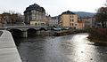
 The Schwarzwasser in Schwarzenberg | |
| Location | |
| Countries | |
| State (DE) | Saxony |
| Region (CZ) | Karlovy Vary |
| Physical characteristics | |
| Source | |
| • location | on the Fichtelberg |
| • coordinates | 50°25′08″N 12°56′16″E / 50.4188194°N 12.9377083°E |
| • elevation | ca. 1,117 m above sea level (NHN) |
| Mouth | |
• location | in Aue into the Zwickauer Mulde |
• coordinates | 50°35′19″N 12°42′07″E / 50.5886806°N 12.702083°E |
• elevation | 342.3 m above sea level (NHN) |
| Discharge | |
| • location | at Aue 1 gauge |
| • average | 6.28 m3/s (222 cu ft/s)[1] |
| • maximum | Average high: 65.8 m3/s (2,320 cu ft/s)[1] Record high: 315 m3/s (11,100 cu ft/s)[1] (in 2002) |
| Basin features | |
| Progression | Zwickauer Mulde→ Mulde→ Elbe→ North Sea |
| Tributaries | |
| • right | Große Mittweida |
| Waterbodies | Reservoirs: Myslivny Reservoir |
The Schwarzwasser (in German) or Černá (in Czech) is a river in Germany and the Czech Republic. The name means 'black'. It is a right tributary of the Zwickauer Mulde in the German state of Saxony. It flows through Schwarzenberg.
Gallery
-
![The Schwarzwasser near Luhy [cz; de]](//upload.wikimedia.org/wikipedia/commons/thumb/2/26/Schwarzwassertal9-2006.jpg/120px-Schwarzwassertal9-2006.jpg) The Schwarzwasser near Luhy
The Schwarzwasser near Luhy -
 The Schwarzwasser above Potůčky
 -
 Aue: mouth of the Schwarzwasser (left) at the Mulde
![The Schwarzwasser near Luhy [cz; de]](/wiki/File:Schwarzwassertal9-2006.jpg)


See also
References
- ^ a b c Hochwasserschutz 2002 im Muldegebiet Sächsisches Landesamt für Umwelt, Landwirtschaft und Geologie; 2009 (pdf)
External links
 Media related to Schwarzwasser (Mulde tributary) at Wikimedia Commons
| International | |
|---|---|
| National | |
This Karlovy Vary Region location article is a stub. You can help Wikipedia by expanding it. |
Categories:
- Pages using gadget WikiMiniAtlas
- Articles with short description
- Short description matches Wikidata
- Coordinates on Wikidata
- Tributaries of the Zwickauer Mulde
- Commons category link is on Wikidata
- Articles with VIAF identifiers
- Articles with NKC identifiers
- Rivers of the Karlovy Vary Region
- Rivers of Saxony
- Rivers of the Ore Mountains
- Johanngeorgenstadt
- Rivers of Germany
- International rivers of Europe
- All stub articles
- Saxony river stubs
- Karlovy Vary Region geography stubs
- Czech Republic river stubs