Santo Antônio do Grama
From WikiProjectMed
Jump to navigation
Jump to search
Municipality in Southeast, Brazil
Santo Antônio do Grama | |
|---|---|
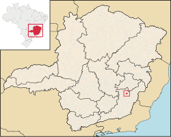
 Location in Minas Gerais state | |
| Coordinates: 20°18′50″S 42°36′32″W / 20.31389°S 42.60889°W / -20.31389; -42.60889 | |
| Country | Brazil |
| Region | Southeast |
| State | Minas Gerais |
| Mesoregion | Zona da Mata |
| Microregion | Ponte Nova |
| Area | |
| • Total | 130.21 km2 (50.27 sq mi) |
| Population (2020 [1]) | |
| • Total | 3,886 |
| • Density | 30/km2 (77/sq mi) |
| Time zone | UTC−3 (BRT) |
| Website | santoantoniodograma.mg.gov.br |
Santo Antônio do Grama is a municipality in the state of Minas Gerais in Brazil. The population is 3,886 (2020 est.) in an area of 130.21 km².
The city became prominent due to the mining accident in March 2018 where a mine piping from Anglo American plc leaked more than 300 tons of ore pulp to the local river, halting the water supply to the population. [2] [3]
References
- ^ IBGE 2020
- ^ Neil Hume (2018-03-13). "Anglo American faces disruption in Brazil". Financial Times. Retrieved 2018-03-14.
- ^ "Brazil investigates Anglo pipe leak". Mining Journal. 2018-03-14. Retrieved 2018-03-14.
External links
- Santo Antônio do Grama on citybrazil.com.br (in Portuguese)
- Santo Antônio do Grama on Explorevale (in Portuguese)
This geographical article relating to Minas Gerais is a stub. You can help Wikipedia by expanding it. |
Retrieved from "https://mdwiki.org/wiki/Santo_Antônio_do_Grama"


