Sainte-Anne River (Les Chenaux)
This article needs additional citations for verification. (October 2023) |
| Sainte-Anne River (Les Chenaux) Telahiar, Wendat (huron) | |
|---|---|
 River's mouth, Sainte-Anne-de-la-Pérade | |
| Location | |
| Country | Canada |
| Province | Quebec |
| Region | Capitale-Nationale, Mauricie |
| Regional County Municipality | La Jacques-Cartier Regional County Municipality, Portneuf Regional County Municipality, Les Chenaux Regional County Municipality |
| Municipalities | Lac-Croche, Stoneham-et-Tewkesbury, Saint-Gabriel-de-Valcartier, Saint-Raymond, Saint-Léonard-de-Portneuf, Sainte-Christine-d'Auvergne, Saint-Gilbert, Saint-Alban, Saint-Casimir, Sainte-Anne-de-la-Pérade |
| Physical characteristics | |
| Source | Lac Sainte-Anne |
| • location | Lac-Croche in Laurentides Wildlife Reserve |
| • coordinates | 47°17′06″N 71°39′36″W / 47.285°N 71.66°W |
| • elevation | 662 m (2,172 ft) |
| Mouth | Estuary of Saint Lawrence |
• location | Saint-Anne-de-la-Pérade |
• coordinates | 46°33′13″N 72°12′22″W / 46.55361°N 72.20611°W |
• elevation | 4 m (13 ft) |
| Length | 123 km (76 mi) |
| Discharge | |
| • location | Sainte-Anne-de-la-Pérade |
| Basin features | |
| Tributaries | |
| • left | (Upward from the mouth) rivière aux Ours, cours d'eau Notre-Dame, Tourilli River, décharge du lac Ball, décharge des lacs Nolin et Johnson, décharge du lac Noyade, décharge des lacs Carreau et Coeur. |
| • right | (Upward from the mouth) Charest River, ruisseau Baillargeon, ruisseau Tessier, Niagarette River, Noire River, ruisseau Sauvageau, Jacquot River, Petit ruisseau l'Heureux, bras du Nord, Verte River, Talayarde River, ruisseau aux Cascades, décharge du lac Chauveau, ruisseau du Pimbina, Chézine River, décharge du lac Henri, décharge du lac Mersac. |
The Sainte-Anne River, a north shore tributary of Saint Lawrence River, the mouth river is located at Sainte-Anne-de-la-Pérade. This river flows in the province of Quebec, Canada.
Administrative regions
- Regional County Municipality: La Jacques-Cartier —Municipalities: Stoneham-et-Tewkesbury, Saint-Gabriel-de-Valcartier
- Regional County Municipality: Portneuf — Municipalities: Saint-Raymond, Saint-Léonard-de-Portneuf, Sainte-Christine-d'Auvergne, Saint-Gilbert, Saint-Alban, Saint-Casimir
- [Regional County Municipality: Les Chenaux — Municipality: Sainte-Anne-de-la-Pérade
It is well known for ice fishing, with the primary catch being Tomcod, (poulamon in French), during the winter at Ste-Anne-de-la-Pérade. A small village builds up from the end of December to mid-February.
It is also regionally known for flooding, especially in St-Raymond, and sometimes in St-Casimir.
Apart from the village areas, forestry, recreational tourism and agriculture are the main economic activities on this hydrographic side.
The surface of the Sainte-Anne river (except the rapids areas) is generally frozen from the beginning of December to the end of March; however, safe circulation on the ice is generally done from the end of December to the beginning of March. The water level of the river varies with the seasons and the precipitation; the spring flood occurs in March or April.
Toponymy
The origin of the name of the river is unknown.[1] Samuel de Champlain gave it the name of Sainte-Marie river in 1609 without specifying its reasons.[1] It was registered under the name of Sainte-Anne river on the map of Jean Bourdon of 1641, an appellation which quickly became essential.[1] The Hurons, meanwhile, call it Telahiar.[1]
The toponym Rivière Sainte-Anne was formalized on December 5, 1968, at the Commission de toponymie du Québec.[1]
Drainage
Sainte-Anne river area [2] - Portneuf county
The major part of the area is drained by the Sainte-Anne river, which flows southwesterly to enter the Saint-Lawrence at Sainte-Anne-de-la-Pérade. The Noire and Niagarette rivers and Charest brook join the Sainte-Anne as tributaries from the west, but no streams enter the main river on its eastern side. This portion of the map-area drains directly into the Saint-Lawrence by La Chevrotière river, Moulin creek, and other smaller streams.
With the exception of the Sainte-Anne river, all these streams flow between banks of unconsolidated deposits, and only rarely have their channels reached bedrock.
Geography
Course
Sainte-Anne begins its course at 662 metres (2,172 ft) above sea level in the Laurentides, in Laurentides Wildlife Reserve, i.e. at the mouth of Lac Sainte-Anne in the unorganized territory of Lac-Croche and the Laurentides Wildlife Reserve. The Lac Sainte-Anne is 4.8 kilometres (3.0 mi) long and 0.5 kilometres (0.31 mi) wide.[3]
From the road bridge (forest road R00300) spanning the Sainte-Anne river, at the mouth of the lac Sainte-Anne, the course of the Sainte-Anne river descends on 140.4 kilometres (87.2 mi) with a drop of 651 metres (2,136 ft), according to the following segments:
Upper course of the Sainte-Anne river (segment of 24.6 kilometres (15.3 mi))
- 3.2 kilometres (2.0 mi) towards the south-east in particular by crossing Lake Gabriella (length: 1.1 kilometres (0.68 mi); altitude: 651 kilometres (405 mi)) and Lake Georgiana (length: 2.2 kilometres (1.4 mi); altitude: 651 kilometres (405 mi)) to the dam at its mouth;
- 1.5 kilometres (0.93 mi) towards the east by forming a hook towards the north, up to the confluence of the outlet of Lake Henry (coming from the south);
- 2.1 kilometres (1.3 mi) eastwards forming an S, to the outlet (coming from the north) of a set of lakes including Holcombe and Nolin lakes;
- 6.3 kilometres (3.9 mi) to the south in a deep valley passing on the west side of Mont des Chutes, to the outlet of a lake (coming from the east);
- 6.8 kilometres (4.2 mi) south in a steep valley, to Markham Creek (coming from the east);
- 4.7 kilometres (2.9 mi) to the south in a deep valley by forming two hooks towards the east at the end of the segment, up to the Chézine River (coming from the northwest)
Intermediate course of the Sainte-Anne river, downstream of the Chézine river (segment of 39.8 kilometres (24.7 mi))
* 4.1 kilometres (2.5 mi) to the south in a deep valley, to the Pimbina stream (coming from the northwest);
- 2.6 kilometres (1.6 mi) to the south crossing a small plain, collecting the outlet of Lake Chauveau (coming from the northwest), then branching east, to the confluence of the Tourilli River (coming from the northeast);
- 11.2 kilometres (7.0 mi) to the south, bypassing a few islands, until the confluence of the Talayarde River (coming from the north-west);
- 11.6 kilometres (7.2 mi) to the south in a deep valley, until the confluence of the Verte River (coming from the north-west);
- 10.3 kilometres (6.4 mi) to the south first by going around an island with a length of 0.9 kilometres (0.56 mi), by going around a second island with a length of 0.8 kilometres (0.50 mi), passing on the west side of Mont Laura-Plamondon, passing in the village of Saint-Raymond, then branching west, to Bras du Nord (coming from the northwest)
Intermediate course of the Sainte-Anne river, downstream from the Bras du Nord (segment of 20.5 kilometres (12.7 mi))
* 13.5 kilometres (8.4 mi) towards the south passing in front of the hamlet Chute-Panet (east bank), bypassing an island, forming a loop towards the east designated Pointe Basse, then branching towards the southwest to the Ford Falls located near Domaine-des-Chutes-Sud (east bank) and Domaine-des-Chutes-Nord (west bank);
- 7.0 kilometres (4.3 mi) southwards passing under the road bridge designated Ponts des Cascades, and passing on the west side of the village of Sainte-Christine-d'Auvergne, up to the confluence from the Jacquot River (coming from the northwest)
Intermediate course of the Sainte-Anne river, downstream of the Jacquot river (segment of 27.6 kilometres (17.1 mi))
* 5.7 kilometres (3.5 mi) to the south by crossing rapids, forming a loop to the east, then crossing other series of rapids, to the discharge (coming from the west) of an unidentified lake;
- 10.7 kilometres (6.6 mi) to the south by forming two loops to the east, and passing in front of the village of Saint-Alban, up to the Saint-Alban dam;
- 1.6 kilometres (0.99 mi) towards the south-west, up to a bend of the river corresponding to a small bay stretching towards the west;
- 4.8 kilometres (3.0 mi) towards the south by forming a curve towards the east to pass near the hamlet "Trou du Diable", up to the railway bridge;
- 4.8 kilometres (3.0 mi) towards the south-west, bypassing a dozen small islands, until the confluence of the Noire River (coming from the North-West)
Lower course of the Sainte-Anne river, upstream of Saint-Casimir (segment of 27.9 kilometres (17.3 mi))
- 13.3 kilometres (8.3 mi) first towards the south while bending slightly towards the west to pass under the bridge of the village of Saint-Casimir, by collecting the Niagarette River (coming from the west), then by bending to the southwest and bypassing the island at Leboeuf, as far as Village-Sainte-Catherine (located on the west bank);
- 8.8 kilometres (5.5 mi) to the south by crossing several series of rapids including the Rapide Sud and the Rapide d'en Bas, as well as bypassing the Tessier Islands and Sadoth, to the Charest River (coming from the northwest);
- 1.9 kilometres (1.2 mi) east to the two bridges of the autoroute 40;
- 1.3 kilometres (0.81 mi) to the east by collecting the Montée d'Enseigne stream (coming from the north), passing under the railway bridge and bending south-east to the village bridge;
- 2.6 kilometres (1.6 mi) to the south, bypassing Île Lacoursière located opposite the hamlet L'Île-à-Lafond (north shore), to its mouth.[4]
The river flows mainly in a south-westerly direction over a length of 123 kilometres (76 mi) to Sainte-Anne-de-la-Pérade, and finally empties into the St. Lawrence river at sea level.[5][full citation needed]
The confluence of the Sainte-Anne river with the St. Lawrence river is located 4.7 kilometres (2.9 mi) downstream of the confluence of the Batiscan River.[3]
Hydrology
The watershed has an area of 2,694 square kilometres (1,040 sq mi).[5] Its average flow at its mouth is 78 m3/s.[citation needed] The main tributaries of the river are, from upstream to downstream, the Tourilli River, the Chézine River, the Talayarde River, the Bras du Nord, Jacquot River, Noire River, Blanche River, Niagarette River and Charest River.[6][full citation needed] It also includes 900 kilometres (560 mi) of watercourse.[6] The basin includes 828 lakes, the most important of which are Lakes Montauban, Long, Blanche, Carillon and Clair.[6]
Geology
Sainte-Anne is part of two geological provinces. Upstream of Saint-Alban, the subsoil is part of the Laurentides, and is composed of igneous rocks and metamorphic, mainly gneiss and granite, resistant to erosion.[7][full citation needed] The river enters the St. Lawrence Lowlands downstream from Saint-Alban and the source rock consists mainly of limestone and shale from the Paleozoic.[7]
The whole is covered with marine and continental deposits from the Quaternary, the thickness of which is approximately 40 metres (130 ft) in the St. Lawrence Lowlands and less than 5 metres (16 ft) in the Laurentians.[7]
Population
It is estimated that there were approximately 16000 people who lived in the Sainte-Anne basin in 2001.[8][full citation needed] The town of Saint-Raymond alone has half the population of the[8] basin. Four other villages are located on the course of the river, namely Sainte-Christine-d'Auvergne, Saint-Alban, Saint-Casimir and Sainte-Anne-de-la-Pérade.
Natural environments
The north of the basin is included in the ZECs (zone d'exploitation contrôlée, 'controlled harvesting zone') of Zec de la Rivière-Blanche and Batiscan-Neilson as well as the Laurentides Wildlife Reserve. The southwest of the basin is included in the Lacs-Long-et-Montauban Regional Park.[9][full citation needed]
The forest dominates, occupying 80% of the hydrographic basin. The public forest, which includes 56% of the forest area, is composed of 58% of mixed forests, 26% of coniferous and 16% of broadleaved.[10][full citation needed] The basin extends over four bioclimatics areas, namely maple grove to linden, maple grove to yellow birch, the fir with yellow birch and the fir white birch.[10]
The river and its tributaries is frequented by 33 species of fish.[11] The main species used for sport fishing living in the river are brook trout (Salvelinus fontinalis), walleye (Sander vitreus) and the smallmouth bass (Micropterus dolomieu).[12][full citation needed]
The river is also recognized as an important spawning ground for the Atlantic tomcod (Microgadus tomcod). There are between 600 and {800 million of individuals who come to breed in the river between December and February, two million of which are fished each year.[13] The spawning ground would have been created in 1894 by a major landslide at Saint-Alban, giving the river a bottom of sand and gravel ideal for the reproduction of fish.[12]
History
The river was known to the St. Lawrence Iroquoians who already practiced there ice fishing around the year 1000.[14]
The Atlantic tomcod population was rediscovered in the river in 1938.[14] Ice fishing quickly became a popular activity, developing a village up to 1200 huts.[14] The combined pressure of commercial fishing and sport fishing caused the decline of the fish population.[14] To remedy this decline, a moratorium on commercial fishing was decreed in 1992 which enabled the tomcod population to recover.[14]
Layout
There are five dams on the Sainte-Anne river, three of which are used for hydroelectric production.[15] These are the power stations of Saint-Alban (8.2 megawatts (11,000 hp)), Chutes-à-Gorry (10.76 megawatts (14,430 hp)) and Glenford (4.2 megawatts (5,600 hp)).[15]
Photos
- Sainte-Anne River (Les Chenaux)
-
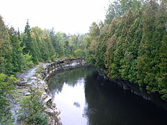
 Rivière Bras-du-Nord (Sainte-Anne), Saint-Raymond
 -
-
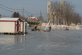
 Fishing hut, bridge over the Chemin du Roy, parish church, Sainte-Anne-de-la-Pérade
 -
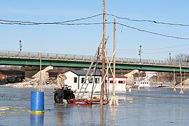
 Chute-Ford dam, near Sainte-Christine-d'Auvergne


Ice fishing on Sainte-Anne River (Les Chenaux)
- Microgadus tomcodal. -Poulamon Atlantique. -Atlantic Tomcod (Walbaum) -Petit poisson des chenaux. -Poisson de Noël. -Loche -(Tommy Cod).
- Mainly from December 26 to February 16
- In Sainte-Anne-de-la-Pérade another village rises
-
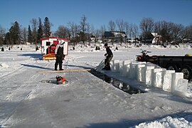
 Strengthening ice by watering
 -
 Installation of the electrical network
 -
 Electrical poles and wires
 -
 Hole and ice blocks
 -
 Resurfacing a cabin with ice, which will be covered with snow


Notes and references
- ^ a b c d e "Rivière Sainte-Anne". Commission de toponymie. Retrieved February 28, 2011.
- ^ Abbé J. W. Laverdière (1936). "Sainte-Anne River Area" (PDF). Province of Quebec, Canada - Department of Mines and Fisheries. p. 33. Retrieved 28 September 2023.
- ^ a b - Atlas of Canada - Department of Natural Resources Canada - Accessed January 23, 2020.
- ^ Atlas of Canada - Department of Natural Resources Canada - Sainte-Anne River
- ^ a b Sainte-Anne Development and Protection Corporation 2006, p. 1
- ^ a b c Sainte-Anne Development and Protection Corporation 2006, pp. 7–8
- ^ a b c Sainte-Anne Development and Protection Corporation 2006, pp. 6–7
- ^ a b Sainte-Anne Development and Protection Corporation 2006, pp. 10–11
- ^ Sainte-Anne Development and Protection Corporation 2006, p. 2
- ^ a b Sainte-Anne Development and Protection Corporation 2006, p. 16
- ^ "Fish diversity: Sainte-Anne river catchment area". Ministry of Sustainable Development, Environment and Parks. Retrieved February 28, 2011.
- ^ a b Sainte-Anne Development and Protection Corporation 2006, pp. 38–39
- ^ Beaudry, René-Pierre (18 January 2011). "Claude Valade in the Kingdom of small fish in the channels". Laurentides Express.
- ^ a b c d e "History". Association of small fish fishing outfitters in the channels inc. Retrieved February 28, 2011.
- ^ a b "Bassin de la rivière Sainte-Anne". Ministry of Natural Resources and Wildlife. Retrieved February 28, 2011.
Bibliography
- Schéma d’aménagement et de développement, RCM Les Chenaux, included municipalitys of Batiscan, Champlain, Notre-Dame-du-Mont-Carmel, Sainte-Anne-de-la-Pérade, Sainte-Geneviève-de-Batiscan, Saint-Luc-de-Vincennes, Saint-Maurice, Saint-Narcisse, Saint-Stanislas et Saint-Prosper, 2022 (French)
See also
- Sainte-Anne-de-la-Pérade
- Saint-Alban
- Saint-Casimir
- Lordship of Sainte-Anne-de-la-Pérade
- Blanche River
- Portneuf Regional County Municipality
- Les Chenaux Regional County Municipality
- List of rivers of Quebec
External links
- Harv and Sfn no-target errors
- Articles needing additional references from October 2023
- All articles needing additional references
- Articles with short description
- Short description is different from Wikidata
- Coordinates on Wikidata
- Articles containing French-language text
- Articles containing Wyandot-language text
- All articles with incomplete citations
- Articles with incomplete citations from January 2020
- All articles with unsourced statements
- Articles with unsourced statements from July 2020
- Lists of coordinates
- Geographic coordinate lists
- Articles with Geo
- Rivers of Capitale-Nationale
- Tributaries of the Saint Lawrence River
- Laurentides Wildlife Reserve