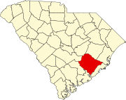
Russellville, South Carolina
Jump to navigation
Jump to search
Russellville, South Carolina | |
|---|---|
| Coordinates: 33°23′50″N 79°58′18″W / 33.39722°N 79.97167°W | |
| Country | United States |
| State | South Carolina |
| County | Berkeley |
| Area | |
| • Total | 3.74 sq mi (9.70 km2) |
| • Land | 3.74 sq mi (9.70 km2) |
| • Water | 0.00 sq mi (0.00 km2) |
| Elevation | 79 ft (24 m) |
| Population | |
| • Total | 380 |
| • Density | 101.50/sq mi (39.18/km2) |
| Time zone | UTC-5 (Eastern (EST)) |
| • Summer (DST) | UTC-4 (EDT) |
| ZIP code | 29479[3] |
| Area code(s) | 843, 854 |
| GNIS feature ID | 1230264[4] |
Russellville is a census-designated place and unincorporated community in Berkeley County, South Carolina, United States. Its population was 488 as of the 2010 census.[5]
Demographics
| Census | Pop. | Note | %± |
|---|---|---|---|
| 2020 | 380 | — | |
| U.S. Decennial Census[6] | |||
References
- ^ "ArcGIS REST Services Directory". United States Census Bureau. Retrieved October 15, 2022.
- ^ "Census Population API". United States Census Bureau. Retrieved October 15, 2022.
- ^ "Russellville SC ZIP Code". zipdatamaps.com. 2023. Retrieved February 17, 2023.
- ^ "Russellville". Geographic Names Information System. United States Geological Survey, United States Department of the Interior.
- ^ "U.S. Census website". United States Census Bureau. Retrieved May 14, 2011.
- ^ "Census of Population and Housing". Census.gov. Retrieved June 4, 2016.
Categories:
- Use mdy dates from July 2023
- Articles with short description
- Short description matches Wikidata
- Coordinates on Wikidata
- Pages using infobox settlement with possible area code list
- Census-designated places in South Carolina
- Unincorporated communities in South Carolina
- Census-designated places in Berkeley County, South Carolina
- Unincorporated communities in Berkeley County, South Carolina
- All stub articles
- South Carolina geography stubs


