Rogolo
Jump to navigation
Jump to search
Rogolo
Rùgul (Lombard) | |
|---|---|
| Comune di Rogolo | |
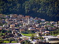
 Rogolo skyline | |
Location of Rogolo  | |
 Rogolo Location of Rogolo in Italy  Rogolo Rogolo (Lombardy) | |
| Coordinates: 46°8′8″N 9°29′14″E / 46.13556°N 9.48722°E | |
| Country | Italy |
| Region | Lombardy |
| Province | Province of Sondrio (SO) |
| Government | |
| • Mayor | Matteo Ferré |
| Area | |
| • Total | 13.0 km2 (5.0 sq mi) |
| Population (2011)[2] | |
| • Total | 564 |
| • Density | 43/km2 (110/sq mi) |
| Time zone | UTC+1 (CET) |
| • Summer (DST) | UTC+2 (CEST) |
| Postal code | 23010 |
| Dialing code | 0342 |
| Website | Official website |
Rogolo (Lombard: Rùgul) is a comune (municipality) in the Province of Sondrio in the Italian region of Lombardy, located about 80 kilometres (50 mi) northeast of Milan and about 30 kilometres (19 mi) west of Sondrio. As of 31 December 2004, it had a population of 568 and an area of 13.0 square kilometres (5.0 sq mi).[3] Rogolo borders the following municipalities: Andalo Valtellino, Cosio Valtellino, Delebio, Mantello, Pedesina, Premana, Rasura.
Demographic evolution

Administration
| Dal | Al | Nome | Carica | Lista/Partito |
|---|---|---|---|---|
| 1990 | 1995 | Bruno Maiorana | Sindaco | Lista Alleanza Democratica |
| 1995 | 1999 | Franco Ferré | Sindaco | Lista Alleanza Democratica |
| 1999 | 2004 | Matteo Dell'Oca | Sindaco | Lista Alleanza Democratica |
| 2004 | 2009 | Matteo Dell'Oca | Sindaco | Lista Alleanza Democratica |
| 2009 | in carica | Matteo Ferré | Sindaco | Lista Alleanza Democratica |
Photo gallery
-
 Rogolo 2010
 -
 Abitato di Rogolo 2010

References
- ^ "Superficie di Comuni Province e Regioni italiane al 9 ottobre 2011". Italian National Institute of Statistics. Retrieved 16 March 2019.
- ^ "Popolazione Residente al 1° Gennaio 2018". Italian National Institute of Statistics. Retrieved 16 March 2019.
- ^ All demographics and other statistics: Italian statistical institute Istat.
External links
This article on a location in the Province of Sondrio is a stub. You can help Wikipedia by expanding it. |
Categories:
- Pages using gadget WikiMiniAtlas
- Pages using the EasyTimeline extension
- Articles with short description
- Short description is different from Wikidata
- Articles containing Lombard-language text
- Articles containing Italian-language text
- Coordinates on Wikidata
- Pages using infobox settlement with image map1 but not image map
- Cities and towns in Lombardy
- Municipalities of the Province of Sondrio
- All stub articles
- Province of Sondrio geography stubs
- Pages using the Kartographer extension