Ranu Kumbolo
Jump to navigation
Jump to search
| Lake Kumbolo | |
|---|---|
| Ranu Kumbolo (Javanese) Danau Kumbolo (Indonesian) | |
 A view of Ranu Kumbolo | |
 Lake Kumbolo | |
| Location | Bromo Tengger Semeru National Park, East Java, Indonesia |
| Coordinates | 8°03′S 112°55′E / 8.050°S 112.917°E |
| Type | Volcanic |
| Primary inflows | Precipitation only |
| Surface area | 15 ha (37 acres) |
| Surface elevation | 2,400 m (7,900 ft) |
| References | [1] |
Ranu Kumbolo (Indonesian: Danau Kumbolo) is a mountainous lake located in Bromo Tengger Semeru National Park, East Java, Indonesia. The lake is part of the easiest route from Ranu Pani to Mount Semeru Peak.
Hiking
There are hiking camp areas around the lake. Ranu Kumbolo is part of the easiest route from Ranu Pani to Mahameru Peak.
Gallery
-
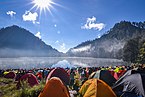 Camping area
 -
 Dutchmen near the lake (c. 1916)
 -
 Ranu Kumbolo circa 1913


References
Wikimedia Commons has media related to Ranu Kumbolo.
This East Java location article is a stub. You can help Wikipedia by expanding it. |
Categories:
- CS1 Indonesian-language sources (id)
- Articles containing Javanese-language text
- Articles containing Indonesian-language text
- Coordinates on Wikidata
- Articles using infobox body of water without alt
- Articles using infobox body of water without pushpin map alt
- Articles using infobox body of water without image bathymetry
- Commons category link from Wikidata
- Lakes of East Java
- All stub articles
- East Java geography stubs
- Mujur basin