Rakke Parish
Jump to navigation
Jump to search
This article includes a list of general references, but it lacks sufficient corresponding inline citations. (February 2022) |
Rakke Parish
Rakke vald | |
|---|---|
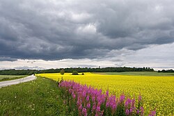
 View towards Emumäe | |
 Rakke Parish within Lääne-Viru County. | |
| Country | |
| County | |
| Administrative centre | Rakke |
| Area | |
| • Total | 226 km2 (87 sq mi) |
| Population (2006) | |
| • Total | 1,924 |
| • Density | 8.5/km2 (22/sq mi) |
| Website | www.rakke.ee |
Rakke Parish (Estonian: Rakke vald) was a rural municipality of Estonia, in Lääne-Viru County.[1] It had a population of 1924 (2006) and an area of 226 km2 (87 sq mi).
Settlements
Rakke Parish had 1 small borough and 30 villages.
- Small borough
- Villages

Ao - Edru - Emumäe - Jäätma - Kaavere - Kadiküla - Kamariku - Kellamäe - Kitsemetsa - Koila - Koluvere - Kõpsta - Lahu - Lammasküla - Lasinurme - Liigvalla - Mõisamaa - Mäiste - Nõmmküla - Olju - Padaküla - Piibe - Räitsvere - Salla - Sootaguse - Suure-Rakke - Tammiku - Villakvere - Väike-Rakke - Väike-Tammiku.
See also
References
- ^ "X-GIS(4) Portal". xgis.maaamet.ee. Retrieved 3 February 2022.
External links
- Official website (in Estonian)
58°58′54″N 26°15′16″E / 58.98167°N 26.25444°E
Categories:
- Pages using gadget WikiMiniAtlas
- Articles with short description
- Short description matches Wikidata
- Articles lacking in-text citations from February 2022
- All articles lacking in-text citations
- Short description is different from Wikidata
- Pages using infobox settlement with bad settlement type
- Pages using infobox settlement with no coordinates
- Articles containing Estonian-language text
- Articles with Estonian-language sources (et)
- Coordinates on Wikidata
- Former municipalities of Estonia
- All stub articles
- Lääne-Viru County geography stubs

