Puerto Rico Highway 134
Jump to navigation
Jump to search
Highway 134 | ||||
|---|---|---|---|---|
| Ruta 134 | ||||
| Route information | ||||
| Maintained by Puerto Rico DTPW | ||||
| Length | 17.5 km[1] (10.9 mi) | |||
| Major junctions | ||||
| South end | ||||
| North end | ||||
| Location | ||||
| Country | United States | |||
| Territory | Puerto Rico | |||
| Municipalities | Lares, Utuado, Hatillo | |||
| Highway system | ||||
| ||||

Puerto Rico Highway 134 (PR-134) is a rural road that travels from Lares, Puerto Rico to Hatillo.[2] This highway begins at its intersection with PR-111 in barrio Lares and ends at its junction with PR-129 in Campo Alegre.[3]
-
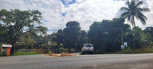 Southbound beginning of PR-134 at PR-129 junction in Campo Alegre, Hatillo

Major intersections
-
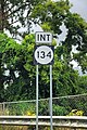 PR-111 east near PR-134 intersection in Lares
 -
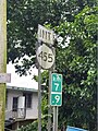 PR-134 south near PR-455 intersection in Bayaney, Hatillo
 -
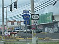 PR-129 north at PR-134 junction in Bayaney, Hatillo


| Municipality | Location | km[1] | mi | Destinations | Notes | |||
|---|---|---|---|---|---|---|---|---|
| Lares | Lares | 0.0 | 0.0 | Southern terminus of PR-134 | ||||
| Utuado |
No major junctions | |||||||
| Hatillo |
No major junctions | |||||||
| Lares |
No major junctions | |||||||
| Hatillo | Bayaney | 7.8– 7.9 | 4.8– 4.9 | |||||
| 8.3 | 5.2 | |||||||
| 11.0 | 6.8 | |||||||
| Aibonito | 13.9 | 8.6 | ||||||
| 14.2 | 8.8 | |||||||
| Campo Alegre | 17.5 | 10.9 | Northern terminus of PR-134 | |||||
| 1.000 mi = 1.609 km; 1.000 km = 0.621 mi | ||||||||
See also
References
- ^ a b Google (2 March 2020). "PR-134" (Map). Google Maps. Google. Retrieved 2 March 2020.
- ^ National Geographic Maps (2011). Puerto Rico (Map). 1:125,000. Adventure Map (Book 3107). Evergreen, Colorado: National Geographic Maps. ISBN 978-1566955188. OCLC 756511572.
- ^ "Tránsito Promedio Diario (AADT)". Puerto Rico Department of Transportation and Public Works (in Spanish). p. 76. Archived from the original on 1 April 2019. Retrieved 5 June 2019.
External links
 Media related to Puerto Rico Highway 134 at Wikimedia Commons
This Puerto Rico road-related article is a stub. You can help Wikipedia by expanding it. |
Categories:
- CS1 Spanish-language sources (es)
- Articles with short description
- Short description matches Wikidata
- Use dmy dates from August 2019
- Articles containing Spanish-language text
- Infobox road maps tracking category
- Infobox road instances in Puerto Rico
- Commons category link from Wikidata
- Highways in Puerto Rico
- All stub articles
- Puerto Rico road stubs