Primero, Ponce, Puerto Rico
Primero | |
|---|---|
![Ponce Darlington Building, (Barrio Primero, Ponce, Puerto Rico) Ponce's first multi-story building, built in 1962,[1] and former home of WRIK-TV.](/wiki/File:Edificio_Ponce_Darlington,_Barrio_Primero,_Ponce,_Puerto_Rico_(DSC05036).jpg) | |
 Location of barrio Primero within the municipality of Ponce shown in red | |
 Primero Location of Puerto Rico | |
| Coordinates: 18°00′29″N 66°37′10″W / 18.007938°N 66.619476°W[2] | |
| Commonwealth | |
| Municipality | |
| Area | |
| • Total | 0.26 sq mi (0.7 km2) |
| • Land | 0.26 sq mi (0.7 km2) |
| • Water | 0 sq mi (0 km2) |
| Elevation | 33 ft (10 m) |
| Population (2010) | |
| • Total | 3,175 |
| • Density | 12,211.5/sq mi (4,714.9/km2) |
| Source: 2010 Census | |
| Time zone | UTC−4 (AST) |
Primero (Barrio Primero) is one of the 31 barrios of the municipality of Ponce, Puerto Rico. Together with Segundo, Tercero, Cuarto, Quinto, and Sexto, Primero is one of the municipality's original six core urban barrios. It was founded in 1878.[4]
Location
Primero is an urban barrio located in the southern section of the municipality, within the Ponce city limits, and southwest of the traditional center of the city, Plaza Las Delicias.
Boundaries
Barrio Primero is bounded on the North by Villa Street, on the South by Ferrocarril and Dr. Ferran Streets, on the West by PR-2R (Carretera Pámpanos / Calle Coto Canas), and on the East by Eugenio Maria de Hostos Avenue and Marina Street.[5]
In terms of barrio-to-barrio boundaries, Primero is bounded in the North by Barrio Segundo, in the South by Canas Urbano, in the West by Barrio Canas Urbano, and in the East by Barrio Cuarto. The communities of Ponce de Leon, Los Maestros, Mariani, and Pedro J. Rosaly are located in Barrio Primero.

Features and demographics
Primero has 0.25 square miles (650,000 m2) of land area and no water area.[6] In 2000, the population of Primero was 3,550. The population density in Primero was 13,997 persons per square mile.[7] [6]
In 2010, the population of Primero was 3,175 persons, and it had a density of 12,211.5 persons per square mile.[8]
| Census | Pop. | Note | %± |
|---|---|---|---|
| 1900 | 1,592 | — | |
| 1910 | 2,385 | 49.8% | |
| 1920 | 2,658 | 11.4% | |
| 1930 | 3,703 | 39.3% | |
| 1940 | 4,846 | 30.9% | |
| 1950 | 6,279 | 29.6% | |
| 1960 | 5,768 | −8.1% | |
| 1970 | 5,289 | −8.3% | |
| 1980 | 4,093 | −22.6% | |
| 1990 | 3,905 | −4.6% | |
| 2000 | 3,550 | −9.1% | |
| 2010 | 3,175 | −10.6% | |
| U.S. Decennial Census 1899 (shown as 1900)[9] 1910-1930[10] 1930-1950[11] 1960[12] 1980-2000[13] 2010[14] | |||
Notable landmarks
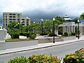
Primero is home to Ponce City Hall on its northeastern end. The Dora Colón Clavell Urban Park, is also found in Barrio Primero. The historic, NRHP-listed, Rosaly-Batiz House, Residencia Zaldo de Nebot on 27 Marina Street, and the Missionary Society of the Methodist Episcopal Church on 132 Villa Street, are also in Barrio Primero.
Gallery
-
 Puerto Rican 'Criollo' food restaurant on Calle Villa and Calle Molina
 -
 Urban Park on Calle Concordia and Calle Marina
 -
 Historic church on Calle Villa, near Calle Torre
.jpg)
JPG.jpg)
.jpg)
See also
References
- ^ Carmelo Rosario Natal. "Ponce en Su Historia Moderna: 1945-2002." Gobierno Municipal de Ponce. First Edition. 2003. Page 55.
- ^ a b "US Gazetteer 2019". US Census. US Government.
- ^ U.S. Geological Survey Geographic Names Information System: Primero barrio
- ^ Barrios de Ponce. Archived 30 September 2015 at the Wayback Machine Antepasados Esclavos.(From: Pedro Tomás de Córdoba. Memorias geográficas, históricas, económicas y estadísticas de la Isla de Puerto Rico.) Retrieved 28 November 2014.
- ^ General Purpose Population Data, Census 2000. Unidad de Sistemas de Información Geográfica, Área de Tecnología de Información Gubernamental, Oficina de Gerencia y Presupuesto. Gobierno de Puerto Rico. Archived 2010-08-12 at the Wayback Machine Retrieved 17 February 2010.
- ^ a b U.S. Census Bureau. Census 2000. Ponce and Its Barrios. (Ponce Municipio, Puerto Rico -- County Subdivision and Place. GCT-PH1. Population, Housing Units, Area, and Density: 2000. Data Set: Census 2000 Summary File 1 (SF 1) 100-Percent Data) Archived 12 February 2020 at archive.today Retrieved 24 April 2010.
- ^ City Melt Retrieved 17 February 2010.
- ^ Puerto Rico:2010:population and housing unit counts.pdf (PDF). U.S. Dept. of Commerce, Economics and Statistics Administration, U.S. Census Bureau. 2010.
- ^ "Report of the Census of Porto Rico 1899". War Department Office Director Census of Porto Rico. Archived from the original on 16 July 2017. Retrieved 21 September 2017.
- ^ "Table 3-Population of Municipalities: 1930 1920 and 1910" (PDF). United States Census Bureau. Archived (PDF) from the original on 17 August 2017. Retrieved 21 September 2017.
- ^ "Table 4-Area and Population of Municipalities Urban and Rural: 1930 to 1950" (PDF). United States Census Bureau. Archived (PDF) from the original on 30 August 2015. Retrieved 21 September 2014.
- ^ Census of Population, 1960: Number of Inhabitants, General Population Characteristics, General Social and Economic Characteristics, and Detailed Characteristics. Characteristics of the population. U.S. Bureau of the Census. 1963. pp. 97–101. Retrieved 10 June 2023.
- ^ "Table 2 Population and Housing Units: 1960 to 2000" (PDF). United States Census Bureau. Archived (PDF) from the original on 24 July 2017. Retrieved 21 September 2017.
- ^ Puerto Rico: 2010 Population and Housing Unit Counts.pdf (PDF). U.S. Dept. of Commerce Economics and Statistics Administration U.S. Census Bureau. 2010. Archived (PDF) from the original on 20 February 2017. Retrieved 2 August 2019.
External links
 Media related to Primero (Ponce) at Wikimedia Commons

- Webarchive template wayback links
- Webarchive template archiveis links
- Articles with short description
- Short description is different from Wikidata
- Use dmy dates from April 2018
- Short description matches Wikidata
- Coordinates on Wikidata
- Commons category link is on Wikidata
- Barrio Primero
- 1878 establishments in Puerto Rico