Portal:Kent/Sandbox
Jump to navigation
Jump to search
DesktopMobile
Test of: Transclude files as random slideshow/sandbox
-
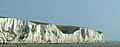 The White Cliffs of Dover (from Kent)
 -
-
 Geological cross-section of Kent, showing how it relates to major towns (from Kent)
 -

-
 Canterbury Cathedral (from Kent)
 -
 The coat of arms of Kent County Council (from Kent)
 -
 An early mention of Kent in the Anglo-Saxon Chronicle between 11th and 12th centuries (from Kent)
 -

-
-

-
-
 A map of Romney Marsh "The history of imbanking and drayning" by William Dugdale (1662). (from Kent)
 -
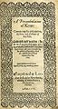 Title page of William Lambarde's Perambulation of Kent (completed in 1570 and published in 1576), a historical description of Kent and the first published county history (from Kent)
 -
 View of the White Cliffs of Dover from France (from Kent)
 -
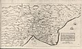
 Hand-drawn map of Kent, Sussex, Surrey and Middlesex from 1575. (from Kent)


Apr2006.jpg)
.jpg)


Test of: Transclude linked excerpts as random slideshow/sandbox
-
 Canterbury Cathedral, formally Christ Church Cathedral, Canterbury, is the cathedral of the archbishop of Canterbury, the leader of the Church of England and symbolic leader of the worldwide Anglican Communion. Located in Canterbury, Kent, it is one of the oldest Christian structures in England and forms part of a World Heritage Site. Its formal title is the Cathedral and Metropolitical Church of Christ, Canterbury. (Full article...)
 -
Greater London is the administrative area of London, England, which is coterminous with the London region. It contains 33 local government districts: the 32 London boroughs, which form a ceremonial county also called Greater London, and the City of London. The Greater London Authority is responsible for strategic local government across the region, and regular local government is the responsibility of the borough councils and the City of London Corporation. Greater London is bordered by the ceremonial counties of Hertfordshire to the north, Essex to the north-east, Kent to the south-east, Surrey to the south, and Berkshire and Buckinghamshire to the west. (Full article...)
-
Ebbsfleet International railway station is in Ebbsfleet Valley, Kent, 10 miles (16 kilometres) east of London, England, near Dartford and the Bluewater shopping centre to the west and Gravesend to the east. The station, part of the Thames Gateway urban regeneration project, is on the High Speed 1 (HS1) rail line, 400 metres (1,300 feet) south-west of Northfleet railway station, off the A2 trunk road, 5 mi (8.0 km) from its junction with the M25 motorway. It served as a primary park-and-rail service for the London 2012 Olympics. (Full article...)
-
The hazelnut is the fruit of the hazel tree and therefore includes any of the nuts deriving from species of the genus Corylus, especially the nuts of the species Corylus avellana. They are also known as cobnuts or filberts according to species. (Full article...)
-
The Diocese of Canterbury is a Church of England diocese covering eastern Kent which was founded by St. Augustine of Canterbury in 597. The diocese is centred on Canterbury Cathedral and is the oldest see of the Church of England. (Full article...)
-
Faversham (/ˈfævərʃəm/) is a market town in Kent, England, 8 miles (13 km) from Sittingbourne, 48 miles (77 km) from London and 10 miles (16 km) from Canterbury, next to the Swale, a strip of sea separating mainland Kent from the Isle of Sheppey in the Thames Estuary. It is close to the A2, which follows an ancient British trackway which was used by the Romans and the Anglo-Saxons, and known as Watling Street. The name is of Old English origin, meaning "the metal-worker's village". (Full article...)
-
A parish council is a civil local authority found in England, which is the lowest tier of local government. They are elected corporate bodies, with variable tax raising powers, and they carry out beneficial public activities in geographical areas known as civil parishes. There are about 10,480 parish and town councils in England. Parish councils may be known by different styles, they may resolve to call themselves a town council, village council, community council, neighbourhood council, or if the parish has city status, it may call itself a city council. However their powers and duties are the same whatever name they carry. (Full article...)
-
The Marlowe Theatre is a 1,200-seat theatre in Canterbury named after playwright Christopher Marlowe, who was born and attended school in the city. It was named a Stage Awards, 2022 UK Theatre of the Year. (Full article...)
-
Dover (/ˈdoʊvər/ DOH-vər) is a town and major ferry port in Kent, South East England. It faces France across the Strait of Dover, the narrowest part of the English Channel at 33 kilometres (21 mi) from Cap Gris Nez in France. It lies south-east of Canterbury and east of Maidstone. The town is the administrative centre of the Dover District and home of the Port of Dover. (Full article...)
-
The Local Government Act 1894 (56 & 57 Vict. c. 73) was an Act of the Parliament of the United Kingdom that reformed local government in England and Wales outside the County of London. The Act followed the reforms carried out at county level under the Local Government Act 1888 (51 & 52 Vict. c. 41). The 1894 legislation introduced elected councils at district and parish level. (Full article...)
-
Smallfilms is a British television production company that made animated TV programmes for children from 1959 until the 1980s. In 2014 the company began operating again, producing a new series of its most famous show, The Clangers, but it became dormant again in 2017, after production of the show was slightly changed. It was originally a partnership between Oliver Postgate (who wrote the scripts, animated the characters, and voiced many of the characters) and Peter Firmin (who made the models of the characters and drew the artwork). Several popular series of short films were made using stop-motion animation, including Clangers, Noggin the Nog and Ivor the Engine. Another Smallfilms production, Bagpuss, came top of a BBC poll to find the favourite British children's programme of the 20th century. (Full article...)
-
Folkestone (/ˈfəʊkstən/ FOHK-stən) is a port town on the English Channel, in Kent, south-east England. The town lies on the southern edge of the North Downs at a valley between two cliffs. It was an important harbour, shipping port and fashionable coastal resort for most part of the 19th and mid 20th centuries. (Full article...)
-
Kent on Sunday was a regional newspaper covering the county of Kent in the United Kingdom. Starting in 2002, it was published on every Sunday of the year and was available from supermarkets, garages and newsagents. The newspaper was the flagship paper of the KOS Media publishing company. In November 2017, it was announced that it would cease publication at the end of the month. (Full article...)
-
Charles John Huffam Dickens (/ˈdɪkɪnz/; 7 February 1812 – 9 June 1870) was an English novelist and social critic who created some of the world's best-known fictional characters, and is regarded by many as the greatest novelist of the Victorian era. His works enjoyed unprecedented popularity during his lifetime and, by the 20th century, critics and scholars had recognised him as a literary genius. His novels and short stories are widely read today. (Full article...)
-
The English Channel, also known as the Channel, is an arm of the Atlantic Ocean that separates Southern England from northern France. It links to the southern part of the North Sea by the Strait of Dover at its northeastern end. It is the busiest shipping area in the world. (Full article...)
-
The Dungeness nuclear power stations are a pair of non-operational nuclear power stations located on the Dungeness headland in the south of Kent, England. (Full article...)
-
The London Borough of Bexley (/ˈbɛksli/ ) is a London borough in south-east London, forming part of Outer London. It has a population of 248,287. The main settlements are Sidcup, Erith, Bexleyheath, Crayford, Welling and Old Bexley. The London Borough of Bexley is within the Thames Gateway, an area designated as a national priority for urban regeneration. The local authority is Bexley London Borough Council. (Full article...)
-
Augustine of Canterbury (early 6th century – most likely 26 May 604) was a Christian monk who became the first archbishop of Canterbury in the year 597. He is considered the "Apostle to the English”. (Full article...)
-
The Wantsum Channel was a strait separating the Isle of Thanet from the north-eastern extremity of the English county of Kent and connecting the English Channel and the Thames Estuary. It was a major shipping route when Britain was part of the Roman Empire, and continued in use until it was closed by silting in the late Middle Ages. Its course is now represented by the River Stour and the River Wantsum, which is little more than a drainage ditch lying between Reculver and St Nicholas-at-Wade and joins the Stour about 1.7 miles (2.7 km) south-east of Sarre. (Full article...)
-
Gillingham Football Club is a professional association football club based in the town of Gillingham, Kent, England. The only Kent-based club in the Football League, the "Gills" play their home matches at Priestfield Stadium. The team competes in League Two, the fourth tier of the English football league system, in the 2023–24 season. (Full article...)
-
Queenborough is a town on the Isle of Sheppey in the Swale borough of Kent in South East England. (Full article...)
-
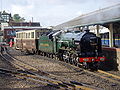
The East Kent Railway (EKR) is a heritage railway in Kent, England. It is located at Shepherdswell station on the London and Chatham to Dover mainline. The line was constructed between 1911 and 1917 to serve the Kent Coalfields. See East Kent Light Railway for details of the original lines. The Kent Collieries were mostly a failure with only Tilmanstone on the line producing any viable commercial coal and commercial traffic over the line.
The line is operated by heritage diesel locomotives. It is home to a collection of heritage diesel locomotives including a British Rail Class 08, DEMU and electric multiple units including an in service British Rail Class 404 built in the 1930s and a more modern British Rail Class 365, which is to be used as a restaurant and a major events venue. (Full article...) -
Swale is a local government district with borough status in Kent, England. The council is based in Sittingbourne, the borough's largest town. The borough also contains the towns of Faversham, Queenborough and Sheerness, along with numerous villages and surrounding rural areas. It includes the Isle of Sheppey and is named after The Swale, the narrow channel which separates Sheppey from the mainland part of the borough. Some southern parts of the borough lie within the Kent Downs, a designated Area of Outstanding Natural Beauty. (Full article...)
-
Surrey (/ˈsʌri/) is a ceremonial county in South East England and one of the home counties. It is bordered by Greater London to the northeast, Kent to the east, East and West Sussex to the south, and Hampshire and Berkshire to the west. The largest settlement is Woking. (Full article...)
-
Thomas Tallis (c. 1505 – 23 November 1585; also Tallys or Talles) was an English composer of High Renaissance music. His compositions are primarily vocal, and he occupies a primary place in anthologies of English choral music. Tallis is considered one of England's greatest composers, and is honoured for his original voice in English musicianship. (Full article...)
