Portal:Andes
The Andes Portal

The Andes (/ˈændiːz/ AN-deez), Andes Mountains or Andean Mountain Range (Spanish: Cordillera de los Andes; Quechua: Anti) are the longest continental mountain range in the world, forming a continuous highland along the western edge of South America. The range is 8,900 km (5,530 mi) long and 200 to 700 km (124 to 435 mi) wide (widest between 18°S and 20°S latitude) and has an average height of about 4,000 m (13,123 ft). The Andes extend from north to south through seven South American countries: Venezuela, Colombia, Ecuador, Peru, Bolivia, Chile and Argentina.
Along their length, the Andes are split into several ranges, separated by intermediate depressions. The Andes are the location of several high plateaus—some of which host major cities such as Quito, Bogotá, Cali, Arequipa, Medellín, Bucaramanga, Sucre, Mérida, El Alto and La Paz. The Altiplano Plateau is the world's second-highest after the Tibetan Plateau. These ranges are in turn grouped into three major divisions based on climate: the Tropical Andes, the Dry Andes, and the Wet Andes.
The Andes Mountains are the highest mountain range outside Asia. The highest mountain outside Asia, Argentina's Aconcagua, rises to an elevation of about 6,961 m (22,838 ft) above sea level. The peak of Chimborazo in the Ecuadorian Andes is farther from the Earth's center than any other location on the Earth's surface, due to the equatorial bulge resulting from the Earth's rotation. The world's highest volcanoes are in the Andes, including Ojos del Salado on the Chile-Argentina border, which rises to 6,893 m (22,615 ft). (Full article...)
Selected articles
-
![Image 1 Llullaillaco from the east Llullaillaco (Spanish pronunciation: [ʎuʎajˈʎako]) is a dormant stratovolcano on the border between Argentina (Salta Province) and Chile (Antofagasta Region). It lies in the Puna de Atacama, a region of tall volcanic peaks on a high plateau close to the Atacama Desert, one of the driest places in the world. Its maximum elevation is most commonly given as 6723 m, making it the second- or third-highest volcano in the world. Despite its height, it is not clear whether the volcano has any glaciers or merely patches of perennial snow and ice. Between 3700 m and 5000 m elevation there is a sparse plant cover, while at lower altitudes the climate is too dry for plants to grow. A species of mouse on Llullaillaco is the highest-living known vertebrate species. The volcano formed during the Pleistocene in two stages, named Llullaillaco I and Llullaillaco II. The oldest rocks are about 1.5 million years old. About 150,000 years ago, the volcano's southeastern flank collapsed, generating a debris avalanche that reached as far as 25 km from the summit. During the last stage, three conspicuous lava flows were emplaced on the summit. The youngest dated rocks are 930 ± 140 years old, but there are reports of activity from the 19th century. (Full article...)](//upload.wikimedia.org/wikipedia/en/d/d2/Blank.png)
Llullaillaco (Spanish pronunciation: [ʎuʎajˈʎako]) is a dormant stratovolcano on the border between Argentina (Salta Province) and Chile (Antofagasta Region). It lies in the Puna de Atacama, a region of tall volcanic peaks on a high plateau close to the Atacama Desert, one of the driest places in the world. Its maximum elevation is most commonly given as 6723 m, making it the second- or third-highest volcano in the world. Despite its height, it is not clear whether the volcano has any glaciers or merely patches of perennial snow and ice. Between 3700 m and 5000 m elevation there is a sparse plant cover, while at lower altitudes the climate is too dry for plants to grow. A species of mouse on Llullaillaco is the highest-living known vertebrate species.
The volcano formed during the Pleistocene in two stages, named Llullaillaco I and Llullaillaco II. The oldest rocks are about 1.5 million years old. About 150,000 years ago, the volcano's southeastern flank collapsed, generating a debris avalanche that reached as far as 25 km from the summit. During the last stage, three conspicuous lava flows were emplaced on the summit. The youngest dated rocks are 930 ± 140 years old, but there are reports of activity from the 19th century. (Full article...) -
Mount Tarn is a small mountain located on the southernmost part of the Strait of Magellan, in Brunswick Peninsula, about 70 km south of Punta Arenas, Chile. It is in the southern extreme of continental Chile very close to Cape Froward, surrounded by historic places such as Fort Bulnes and Puerto del Hambre (Port Famine).
From the summit it is possible to see the Strait of Magellan, Dawson and Tierra del Fuego islands, and many other smaller ones; the Darwin Mountain Range, Mount Sarmiento, and most of the Brunswick Peninsula. (Full article...) -
Cerro Escorial is a stratovolcano at the border of Argentina and Chile. It is part of the Corrida de Cori volcanic group and its youngest member. A well-preserved 1-kilometre-wide (0.6 mi) crater forms its summit area. Lava flows are found on the Chilean and smaller ones on the Argentinian side, the former reaching as far as 3–4 kilometres (1.9–2.5 mi) from the volcano. One of these is dated 342,000 years ago by argon-argon dating.
Off the western coast of South America, the Nazca Plate subducts beneath the South America Plate. This process has given rise to the Andes mountain chain and the Altiplano-Puna high plateau, which formed through shortening of the crust that lasted until 1 million years ago. Cerro Escorial rises from the Puna, which is dissected at Cerro Escorial by the Archibarca lineament; it is a strike-slip fault that has facilitated the ascent of magma. (Full article...) -
Huascarán (Spanish pronunciation: [waskaˈɾan]) (Quechua: Waskaran), Nevado Huascarán or Mataraju is a mountain located in Yungay Province, Department of Ancash, Peru. It is situated in the Cordillera Blanca range of the western Andes. The southern summit of Huascarán (Huascarán Sur), which reaches 6,768 metres (22,205 ft), is the highest point in Peru, the northern Andes (north of Lake Titicaca), and in all of the earth's Tropics. Huascarán is the 4th highest mountain in South America after Aconcagua, Ojos del Salado, and Monte Pissis. Huascarán is ranked 25th by topographic isolation. (Full article...) -
Salcantay, Salkantay or Sallqantay (in Quechua) is the highest peak in the Vilcabamba mountain range, part of the Peruvian Andes. It is located in the Cusco Region, about 60 km (40 mi) west-northwest of the city of Cusco. It is the 38th-highest peak in the Andes and the twelfth-highest in Peru. However, as a range highpoint in deeply incised terrain, it is the second most topographically prominent peak in the country, after Huascarán.
Salcantay's proximity to Machu Picchu makes trekking around it an alternative to the oversubscribed Inca Trail; this is known as the Salkantay trek. (Full article...) -

The Titicaca orestias, Lake Titicaca orestias, or Lake Titicaca flat-headed fish (Orestias cuvieri), also known by its native name amanto, is a likely extinct freshwater killifish from Lake Titicaca in South America. It belongs in the pupfish genus Orestias, endemic to lakes, rivers and streams in the Andean highlands. With a total length of up to 27 cm (10.6 in), it was the largest member in that genus. In the hope that an undiscovered population remains, it is listed as Data Deficient by the IUCN. Despite its common name, it is not the only Orestias from Lake Titicaca.
Its mouth was nearly turned upwards, thereby giving the flat head a concave shape. The head took up nearly a third of the whole body length. The upperside was greenish-yellow to umber. The lower jaw was black. Its scales were oddly light coloured at their centre. The scales of the young were blotched. (Full article...) -
Lake Titicaca (/tɪtɪˈkɑːkə/; Spanish: Lago Titicaca [ˈlaɣo titiˈkaka]; Quechua: Titiqaqa Qucha) is a large freshwater lake in the Andes mountains on the border of Bolivia and Peru. It is often called the highest navigable lake in the world. Titicaca is the largest lake in South America both in terms of the volume of water and surface area.
Lake Titicaca has a surface elevation of 3,812 m (12,507 ft). The "highest lake" claim is generally considered to refer to commercial craft. Numerous smaller lakes around the world are at higher elevations. For many years, the largest vessel afloat on the lake was the 2,200-ton (2,425 U.S. tons), 79 m (259 ft) SS Ollanta. Today, the largest vessel is most likely the similarly sized train barge/float Manco Capac, operated by PeruRail. (Full article...) -
The Sierra Nevada National Park (SNNP) is a National Park of Venezuela located between the states of Mérida and Barinas in western Venezuela. It was created on May 2, 1952, by decree of President Germán Suárez Flamerich, in order to protect the Sierra Nevada de Mérida in the Andes.
It was the second national park decreed, after Henri Pittier National Park, which became the first Venezuelan national park 15 years earlier. (Full article...) -
El Cocuy National Park is a national park located in the Andes Mountains within the nation of Colombia. Its official name is Parque Nacional Natural El Cocuy. (Full article...) -
Sangay (also known as Macas, Sanagay, or Sangai) is an active stratovolcano in central Ecuador. It exhibits mostly strombolian activity. Geologically, Sangay marks the southern boundary of the Northern Volcanic Zone, and its position straddling two major pieces of crust accounts for its high level of activity. Sangay's approximately 500,000-year-old history is one of instability; two previous versions of the mountain were destroyed in massive flank collapses, evidence of which still litters its surroundings today.
Due to its remoteness, Sangay hosts a significant biological community with fauna such as the mountain tapir, giant otter, Andean cock-of-the-rock and king vulture. Since 1979, its ecological community has been protected as part of the Sangay National Park. Although climbing the mountain is hampered by its remoteness, poor weather conditions, river flooding, and the danger of falling ejecta, the volcano is regularly climbed, a feat first achieved by Robert T. Moore in 1929. (Full article...) -
Artesonraju is a pyramidal mountain peak located near the city of Caraz in the Cordillera Blanca mountain range in the Peruvian Andes. It is located at the Peruvian province of Huaylas and its slopes are within two cities: Santa Cruz and Caraz. Its summit has an elevation of 6,025 metres (19,767 ft) (or 5,999 metres (19,682 ft) according to the IGN-Peru map). It is one of many prominent peaks (2772 metres) located within the boundaries of Peru's Huascarán National Park.
Artesonraju has two distinguished climbing routes. Due to their difficulties, Artesonraju is seldom successfully climbed in comparison to other well known mountains in the Cordillera Blanca. This mountain is the inspiration for the current production logo for Paramount Pictures. (Full article...) -
Cerro Macá is a stratovolcano located to the north of the Aisén Fjord and to the east of the Moraleda Channel, in the Aysén del General Carlos Ibáñez del Campo Region of Chile. This glacier-covered volcano lies along the regional Liquiñe-Ofqui Fault Zone.
Cerro Macá is a relatively small volcano with a volume of only 39 cubic kilometres (9.4 cu mi). It has a summit elevation of approximately 2,300 m above sea level and features glaciers that in 2011 covered an area of 27.62 square kilometres (10.66 sq mi). The edifice is partially eroded and a sector collapse is probably the origin of a large steep sided depression in the summit area. Pyroclastic cones with associated lava flows are found on its southwestern flank but also on the other slopes of the volcano, as far down as sea level and in the Bahia Aysen. (Full article...) -
The Dry Andes (Spanish: Andes áridos) is a climatic and glaciological subregion of the Andes. Together with the Wet Andes it is one of the two subregions of the Argentine and Chilean Andes. The Dry Andes runs from the Atacama Desert in northern Chile and Northwest Argentina south to a latitude of 35°S in Chile. In Argentina the Dry Andes reaches 40°S due to the leeward effect of the Andes. According to Luis Lliboutry
the Dry Andes can be defined by the distribution of penitentes. The southernmost well-developed penitentes are found on Lanín Volcano.
Rock glaciers occur in parts of the Dry Andes, but are lacking in the more southern Wet Andes. In the Dry Andes, ordinary glaciers develop usually at higher altitudes than rock glaciers. Around Aconcagua rock glaciers reach altitudes as a low as 900 m a.s.l. (Full article...) -
Jirishanca is a 6,094-metre-high (19,993 ft) mountain in the Huayhuash mountain range in west central Peru, part of the Andes. Other sources cite a height of 6,125 metres (20,095 ft). It is the tenth highest peak in Peru and the third in the Huayhuash range (after Yerupajá and Siula Grande). Jirishanca translates as "hummingbird bill peak". (Full article...) -

Nevado Sajama ([neˈβaðo saˈxama]; Aymara: Chak Xaña) is an extinct volcano and the highest peak in Bolivia. The mountain is located in Sajama Province, in Oruro Department. It is situated in Sajama National Park and is a composite volcano consisting of a stratovolcano on top of several lava domes. It is not clear when it erupted last but it may have been during the Pleistocene or Holocene.
The mountain is covered by an ice cap, and Polylepis tarapacana trees occur up to 5,000 metres (16,000 ft) elevation. (Full article...) -
Volcán Marmolejo is a 6,108 m (20,039 ft) high Pleistocene stratovolcano in the Andes on the border between Argentina and Chile. It is located 9 km (6 mi) NNE of the active San José volcano, and is the southernmost 6,000 m (19,685 ft)-plus peak in the world. The Argentine portion is within the Argentinean protection area of Provincial Reserve for Multiple Use and Natural Recreation Manzano / Portillo de Piuquenes. It is on the border of two provinces: Argentinean province of Mendoza and Chilean province of Cordillera. Its slopes are within the administrative boundaries of the two cities: Argentinean city of Tunuyán and the Chilean commune of San José de Maipo. (Full article...) -
The Pico Pan de Azúcar, at 4680 meters above sea level, is the ninth highest mountain of Venezuela, and the third highest of the Sierra de la Culata range in the Mérida State. Its name, which translates as "Bread of Sugar", is due to the sandy slopes of the mountain, which resembles "Pan dulce", a kind of bread sprinkled with sugar eaten in the country. The summit offers a scenic view, including Lake Maracaibo, Sierra Nevada de Mérida and the surrounding mountains of the Sierra de la Culata. (Full article...)
-
Tungurahua (/tʊŋɡʊˈrɑːwə/; from Quichua tunguri (throat) and rahua (fire), "Throat of Fire") is an active stratovolcano located in the Cordillera Oriental of Ecuador. The volcano gives its name to the province of Tungurahua. Volcanic activity restarted on August 19, 1999, and is ongoing , with several eruptive episodes since then, the most recent lasting from February 26 to March 16, 2016. (Full article...) -

Coropuna is a dormant compound volcano located in the Andes mountains of southeast-central Peru. The upper reaches of Coropuna consist of several perennially snowbound conical summits, lending it the name Nevado Coropuna in Spanish. The complex extends over an area of 240 square kilometres (93 sq mi) and its highest summit reaches an altitude of 6,377 metres (20,922 ft) above sea level. This makes the Coropuna complex the third-highest of Peru. Its thick ice cap is the most extensive in Earth's tropical zone, with several outlet glaciers stretching out to lower altitudes. Below an elevation of 5,000 metres (16,000 ft), there are various vegetation belts which include trees, peat bogs, grasses and also agricultural areas and pastures.
The Coropuna complex consists of several stratovolcanoes. These are composed chiefly of ignimbrites and lava flows on a basement formed by Middle Miocene ignimbrites and lava flows. The Coropuna complex has been active for at least five million years, with the bulk of the current cone having been formed during the Quaternary. Coropuna has had two or three Holocene eruptions 2,100 ± 200 and either 1,100 ± 100 or 700 ± 200 years ago which generated lava flows, plus an additional eruption which may have taken place some 6,000 years ago. Current activity occurs exclusively in the form of hot springs. (Full article...) -
Orestias is a genus of pupfish. Older systematics classified them into the own family Orestiidae. They are found in lakes, rivers and springs in the Andean highlands of South America, and several species are considered threatened. They are egg-laying fish that feed on small animals and plant matter. The largest species can reach a total length of 27 cm (10.6 in), but most remain far smaller. Their most characteristic feature is the absence of the ventral fin, although this is shared by a few other pupfish. Despite their moderate to small size, they are important to local fisheries and a few species are farmed.
Several species are locally and colloquially known as carache. The name of the genus is a reference to Orestes, a Greek mythological character who Valenciennes described as the "nymph of the mountains". (Full article...) -
Simplified sketch of the present-situation along most of the Andes
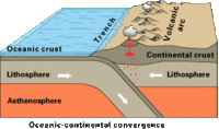
The Andean orogeny (Spanish: Orogenia andina) is an ongoing process of orogeny that began in the Early Jurassic and is responsible for the rise of the Andes mountains. The orogeny is driven by a reactivation of a long-lived subduction system along the western margin of South America. On a continental scale the Cretaceous (90 Ma) and Oligocene (30 Ma) were periods of re-arrangements in the orogeny. The details of the orogeny vary depending on the segment and the geological period considered. (Full article...) -
The Illinizas are a pair of volcanic mountains that are located in the north of Latacunga, Cotopaxi, Ecuador. They are located in the Illinizas Ecological Reserve (Spanish: Reserva Ecológica Los Illinizas). These twin mountains are separated by a saddle that is about a kilometer long. The peaks are among the highest in Ecuador, with Illiniza Sur standing slightly taller than Illiniza Norte, its northern counterpart, at 5245 metres and 5126 metres respectively.
Most guidebooks (for example, Lonely Planet Ecuador, Ecuador: A Climbing Guide) spell the mountain with only one "l" as in Iliniza. The name Illinizas is derived from the Kunza words for "masculine hill." (Full article...) -
Rondoy (possibly from Quechua runtuy: "to hail" or "to lay an egg") is a 5,870-metre-high (19,259 ft) mountain in the north of the Huayhuash mountain range in the Andes of Peru. It is located in the Ancash Region, Bolognesi Province, Pacllón District, and in the Huánuco Region, Lauricocha Province, Queropalca District. Rondoy lies north of Yerupajá and Jirishanca and southwest of Lake Mitococha. (Full article...) -
Pico El Toro is a mountain in the Andes of Venezuela. It has a height of 4755 metres. (Full article...)
-
Mount Darwin (Spanish: Monte Darwin) is a peak in Isla Grande de Tierra del Fuego forming part of the Cordillera Darwin, the southernmost range of the Andes, just to the north of the Beagle Channel. It is 2,438 m (7,999 ft) high.
Monte Darwin was for a long time considered as the highest peak in Tierra del Fuego, but that distinction corresponds to a nearby mountain unofficially named Monte Shipton (also somewhat confusingly referred to as Darwin or Agostini-Darwin), which is about 2,580 m (8,460 ft) high and is located at . Both peaks are best climbed in late December, January, February and March. Monte Shipton was first climbed in 1962 by Eric Shipton, E. Garcia, F. Vivanco and C. Marangunic. (Full article...)
![Image 1 Llullaillaco from the east Llullaillaco (Spanish pronunciation: [ʎuʎajˈʎako]) is a dormant stratovolcano on the border between Argentina (Salta Province) and Chile (Antofagasta Region). It lies in the Puna de Atacama, a region of tall volcanic peaks on a high plateau close to the Atacama Desert, one of the driest places in the world. Its maximum elevation is most commonly given as 6723 m, making it the second- or third-highest volcano in the world. Despite its height, it is not clear whether the volcano has any glaciers or merely patches of perennial snow and ice. Between 3700 m and 5000 m elevation there is a sparse plant cover, while at lower altitudes the climate is too dry for plants to grow. A species of mouse on Llullaillaco is the highest-living known vertebrate species. The volcano formed during the Pleistocene in two stages, named Llullaillaco I and Llullaillaco II. The oldest rocks are about 1.5 million years old. About 150,000 years ago, the volcano's southeastern flank collapsed, generating a debris avalanche that reached as far as 25 km from the summit. During the last stage, three conspicuous lava flows were emplaced on the summit. The youngest dated rocks are 930 ± 140 years old, but there are reports of activity from the 19th century. (Full article...)](/wiki/File:Blank.png)
.jpg)


Did you know...
- ... that the 1930s Polish Andean expeditions have been credited with several first ascents and the tracing of a new route to the summit of Aconcagua, the Andes' highest peak?
Need help?
Do you have a question about Andes that you can't find the answer to?
Consider asking it at the Wikipedia reference desk.
General images
-
 Peruvian farmers sowing maize and beans (from Andes)
 -

-

-
 Pico Humboldt at sunset (from Andes)
 -

-
 Aerial view of Valle Carbajal in the Tierra del Fuego. The Andes range is about 200 km (124 mi) wide throughout its length, except in the Bolivian flexure where it is about 640 kilometres (398 mi) wide. (from Andes)
 -
 The seaward tilting of the sedimentary strata of Salto del Fraile Formation in Peru was caused by the Andean orogeny. (from Andean orogeny)
 -
 Topographic map of the Andes by the NASA. The southern and northern ends of the Andes are not shown. The Bolivian Orocline is visible as a bend in the coastline and the Andes lower half of the map. (from Andean orogeny)
 -
 Bolivian Andes (from Andes)
 -
 Ulluco: Common crop of the Andean region (from Andean agriculture)
 -

-
 Map of the Andean region of South America (from Andean agriculture)
 -
 Irrigating land in the Peruvian Andes (from Andes)
 -
 Pacha Mama Ceremony (from Andean agriculture)
 -
 Parinacota, Bolivia/Chile (from Andes)
 -

-

-
 Mashua tubers (from Andean agriculture)
 -
 Map of a north-south sea-parallel pattern of rock ages in western Colombia. This pattern is a result of the Andean orogeny. (from Andean orogeny)
 -
 Central Andes (from Andes)
 -
 View of Cuernos del Paine in Torres del Paine National Park, Chile (from Andes)
 -
 Frederic Edwin Church, Heart of the Andes, 1859. (from Andes)
 -

-

-
 Simplified sketch of the present-situation along most of the Andes (from Andean orogeny)
 -
 A male Andean cock-of-the-rock, a species found in humid Andean forests and the national bird of Peru (from Andes)
 -
 Nevado del Huila, Colombia (from Andes)
 -
 Laguna de Sonso tropical dry forest in Northern Andes (from Andes)
 -

-
 Syncline next to Nordenskjöld Lake in Torres del Paine National Park. The syncline formed during the Andean orogeny. (from Andean orogeny)
 -

-
 Paleogeography of the Late Cretaceous South America. Areas subject to the Andean orogeny are shown in light grey while the stable cratons are shown as grey squares. The sedimentary formations of Los Alamitos and La Colonia that formed in the Late Cretaceous are indicated. (from Andean orogeny)
 -


%E2%80%93Valle_Carbajal_01.jpg)


.jpg)


.jpg)
.JPG)


.jpg)

.jpg)


Subcategories

- Select [►] to view subcategories
Related portals
Subtopics
Associated Wikimedia
The following Wikimedia Foundation sister projects provide more on this subject:
-
 Commons
Free media repository -
 Wikibooks
Free textbooks and manuals -
 Wikidata
Free knowledge base -
 Wikinews
Free-content news -
 Wikiquote
Collection of quotations -
 Wikisource
Free-content library -
 Wikiversity
Free learning tools -
 Wiktionary
Dictionary and thesaurus


