Port of Kołobrzeg
Jump to navigation
Jump to search
| Port of Kołobrzeg | |
|---|---|
 Aerial view of the entrance to the Port of Kołobrzeg (2021) | |
 Click on the map for a fullscreen view | |
| Location | |
| Country | Poland |
| Location | Kołobrzeg |
| Coordinates | 54°10′46″N 15°33′19″E / 54.17944°N 15.55528°E |
| UN/LOCODE | PLKOL[1] |
| Details | |
| Opened | 13th century[2] |
| Operated by | Kołobrzeg Seaport Authority, Polish Navy |
| Owned by | City of Kołobrzeg, Polish Navy |
| Statistics | |
| Annual cargo tonnage | 277,800 (2023)[3] |
| Passenger traffic | 290,000 (2022)[4] |
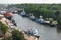
The Port of Kołobrzeg [kɔˈwɔbʐɛk] ⓘ (in Polish generally Port Kołobrzeg) is a Polish seaport in Kołobrzeg, Poland at the Baltic Sea located at the Parsęta river. Port has a yacht harbour, fishing harbour, ferry harbour.
A lighthouse stands on "Fort Ujście"; it was built after the World War II. The old lighthouse was standing ~20 meters closer to sea. When Germans were evacuating from Kołobrzeg, they destroyed the old lighthouse because it was a strategic point for allies.
In 2023, cargo traffic in the seaport equaled 277,800 tons.[3]
In 2022, the port recorded 290,000 passengers.[4]
Gallery
-
 Breakwater at the mouth of river Parsęta
 -


See also
References
Wikimedia Commons has media related to Port of Kołobrzeg.
Wikimedia Commons has media related to Port of Kołobrzeg.
- ^ "UNLOCODE (Pl) - POLAND". service.unece.org. Retrieved 2023-08-07.
- ^ Gaziński, Radosław (2017). "Zarys Dziejów Portu Kołobrzeskiego W XVI–XVIII Wieku" [Outline of the History of Port of Kołobrzeg in the 16th-18th Centuries]. Instytut Historii i Stosunków Międzynarodowych, Uniwersytet Szczeciński. doi:10.18276/sm.2017.30-02. eISSN 2353-303X. ISSN 0137-3587.
- ^ a b "Port Kołobrzeg. Duży wzrost przeładunków" [Port of Kołobrzeg. Large increase in transshipments]. GospodarkaMorska.pl (in Polish). Retrieved 2024-01-20.
- ^ a b "The Management Board of Sea Port Kołobrzeg summed up 2022". MarinePoland.com. 2023-01-31.
This West Pomeranian Voivodeship location article is a stub. You can help Wikipedia by expanding it. |
Categories:
- Pages using the Phonos extension
- CS1 Polish-language sources (pl)
- Articles with short description
- Short description matches Wikidata
- Infobox mapframe without OSM relation ID on Wikidata
- Commons link is defined as the pagename
- Commons category link is on Wikidata
- Ports and harbours of Poland
- Buildings and structures in Kołobrzeg
- All stub articles
- West Pomeranian geography stubs
- Pages using the Kartographer extension