Port Mayaca Lock and Dam
| Port Mayaca Lock and Dam | |
|---|---|
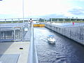
 View through open lakeside gates of the Port Mayaca Navigational Lock, onto Lake Okeechobee. | |
| Official name | Port Mayaca Lock and Dam |
| Location | |
| Opening date | 1977 |
| Construction cost | $13,100,000 |
| Dam and spillways | |
| Length | 400 feet |
| Width (base) | 56 feet |
The Port Mayaca Lock is a navigable lock and dam on the Okeechobee Waterway (St. Lucie Canal), adjacent to U.S. Route 441 and U.S. Route 98 at Canal Point, in Martin County, Florida, United States.[1]
It is located near Port Mayaca at latitude 26° 59" 5', longitude -80° 37" 5'.[2]
Port Mayaca Lock is open daily from 7:00am to 5:00pm. New Lock hour as of 1 April 2015.[3]
The total cost of construction was $13.1 million.[3]
Purpose
This structure was created to help raise the water level in the lake, for the purpose of retaining fresh water for agricultural use, city water supply, and for navigation. It also serves for regulating flood control water into the Everglades during hurricane season.[4] When polluted lake water is released into the C-44 St. Lucie Canal, the water carries or can spawn algae blooms that release cyanotoxins that may cause nausea, vomiting, skin rashes, coughing, shortness of breath, and achy limbs and joints. Some suspect that small pets have been killed by this airborne toxin.[5]
Technical information
The lock chamber is 56 feet (17 m) wide by 400 feet (120 m) long, and 14 feet (4.3 m) deep. The lift distance between the St. Lucie Canal and Lake Okeechobee is normally 1/2 to 2 feet (0.61 m). The channel width is 100 feet (30 m), and 8 feet (2.4 m) deep.[3]
The lock gates are "sector gates" (pie-slice shaped), and are made of steel. The spillway is ogee-type concrete, with 4 vertical lift gates.[3]
The discharge capacity is 14,800 cubic feet per second (420 m3/s).[3]
Radio channel
This lock operates on Marine VHF radio channel 13.[3]
Gallery
-
 Boaters anchored lock wall as the canal-side gates close.
 -
 Boater exits as canal-side gates closed behind and Lake Okeechobee lakeside gates opening.
 -
 U.S. Army Corps of Engineer personnel overlooks the closing of the lakeside gates.
 -
 Canal 59 in the foreground and Control Structure S-191, which controls water flow into Lake Okeechobee.


See also
References
- ^ "New Port Mayaca Lock FL" (PDF). Archived from the original (PDF) on 2006-09-27. Retrieved 2010-08-25.
- ^ "Port Mayaca Lock - Florida, United States". Marinas.com. Retrieved 2010-08-25.
- ^ a b c d e f "Archived copy" (PDF). Archived from the original (PDF) on 2011-07-25. Retrieved 2010-08-25.
{{cite web}}: CS1 maint: archived copy as title (link) - ^ American Canal Society Report Archived 2006-09-27 at the Wayback Machine
- ^ Smith, Cheryl (30 October 2023). "What are Lake Okeechobee discharges? Risks include water pollution and toxic algae blooms". Treasure Coast. Retrieved 9 March 2024.
External links
26°59′04″N 80°37′16″W / 26.984531°N 80.621105°W
This Florida-related article is a stub. You can help Wikipedia by expanding it. |
- CS1 maint: archived copy as title
- Webarchive template wayback links
- Articles with short description
- Short description is different from Wikidata
- Coordinates on Wikidata
- Dams in Florida
- United States Army Corps of Engineers dams
- Transport infrastructure completed in 1977
- Dams completed in 1977
- 1977 establishments in Florida
- Locks of Florida
- All stub articles
- Florida stubs