Poole, Kentucky
Jump to navigation
Jump to search
Poole, Kentucky | |
|---|---|
 | |
 Poole  Poole | |
| Coordinates: 37°38′25″N 87°38′39″W / 37.64028°N 87.64417°W | |
| Country | United States |
| State | Kentucky |
| Counties | Webster, Henderson |
| Area | |
| • Total | 0.98 sq mi (2.54 km2) |
| • Land | 0.97 sq mi (2.51 km2) |
| • Water | 0.01 sq mi (0.03 km2) |
| Elevation | 498 ft (152 m) |
| Population (2020) | |
| • Total | 354 |
| • Density | 364.95/sq mi (140.87/km2) |
| Time zone | UTC-6 (Central (CST)) |
| • Summer (DST) | UTC-5 (CST) |
| ZIP code | 42444 |
| FIPS code | 21-62202 |
| GNIS feature ID | 501069[2] |
Poole is an unincorporated community and census-designated place (CDP) in Webster and Henderson counties, Kentucky, United States. The community is on U.S. Route 41A, 15 miles (24 km) south of Henderson and 20 miles (32 km) north of Providence. The center of Poole is in northern Webster County, and the community extends north into southern Henderson County.
Demographics
| Census | Pop. | Note | %± |
|---|---|---|---|
| 2020 | 354 | — | |
| U.S. Decennial Census[3] | |||
References
- ^ "2020 U.S. Gazetteer Files". United States Census Bureau. Retrieved March 18, 2022.
- ^ U.S. Geological Survey Geographic Names Information System: Poole, Kentucky
- ^ "Census of Population and Housing". Census.gov. Retrieved June 4, 2016.
Municipalities and communities of Webster County, Kentucky, United States | ||
|---|---|---|
| Cities |  | |
| CDPs | ||
| Other unincorporated communities | ||
| Footnotes | ‡This populated place also has portions in an adjacent county or counties | |
Municipalities and communities of Henderson County, Kentucky, United States | ||
|---|---|---|
| Cities | 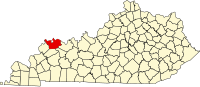 | |
| CDPs | ||
| Other communities | ||
| Ghost town | ||
| Footnotes | ‡This populated place also has portions in an adjacent county or counties | |
This Webster County, Kentucky state location article is a stub. You can help Wikipedia by expanding it. |
Categories:
- Pages using gadget WikiMiniAtlas
- Use mdy dates from July 2023
- Articles with short description
- Short description is different from Wikidata
- Coordinates on Wikidata
- Census-designated places in Webster County, Kentucky
- Census-designated places in Henderson County, Kentucky
- Census-designated places in Kentucky
- All stub articles
- Kentucky geography stubs