Piedmont, Quebec
Jump to navigation
Jump to search
Piedmont | |
|---|---|
 | |
 Location within Les Pays-d'en-Haut RCM | |
 Piedmont Location in central Quebec | |
| Coordinates: 45°54′N 74°08′W / 45.9°N 74.13°W[1] | |
| Country | |
| Province | |
| Region | Laurentides |
| RCM | Les Pays-d'en-Haut |
| Constituted | September 22, 1923 |
| Government | |
| • Mayor | Clément Cardin |
| • Federal riding | Laurentides—Labelle |
| • Prov. riding | Bertrand |
| Area | |
| • Total | 24.70 km2 (9.54 sq mi) |
| • Land | 24.36 km2 (9.41 sq mi) |
| Population (2021)[3] | |
| • Total | 3,476 |
| • Density | 142.7/km2 (370/sq mi) |
| • Pop (2016–21) | |
| Time zone | UTC−5 (EST) |
| • Summer (DST) | UTC−4 (EDT) |
| Postal code(s) | |
| Area code(s) | 450 and 579 |
| Website | www |
Piedmont is a small municipality within the Les Pays-d'en-Haut Regional County Municipality, Quebec, Canada, in the Laurentian Mountains of the administrative region of Laurentides. It is located along the North River and Autoroute 15 and Route 117, north of Montreal.
Police services are provided by the Régie intermunicipale de police de la Rivière-du-Nord, which also serves Prévost and some other nearby communities in the Laurentians.
Demographics
Population trend:[4]
- Population in 2021: 3476 (2016 to 2021 population change: 17.8%)
- Population in 2016: 2950 (2011 to 2016 population change: 8.4%)
- Population in 2011: 2721 (2006 to 2011 population change: 14.0%)
- Population in 2006: 2386 (2001 to 2006 population change: 12.4%)
- Population in 2001: 2122
- Population in 1996: 1862
- Population in 1991: 1462
Private dwellings occupied by usual residents: 1822 (total dwellings: 2385)
Mother tongue:
- English as first language: 5.5%
- French as first language: 88.4%
- English and French as first language: 2.2%
- Other as first language: 3.3%
-
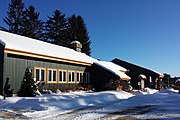 Piedmont town hall
 -
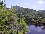 Rivière du Nord in Piedmont

.JPG)
Education
This section needs expansion. You can help by adding to it. (September 2017) |
Sir Wilfrid Laurier School Board operates Anglophone public schools:
- Morin Heights Elementary School (serves a portion) in Morin-Heights[5]
- Saint Adèle Elementary School (serves a portion) in Saint-Adèle[6]
See also
References
- ^ "Banque de noms de lieux du Québec: Reference number 48955". toponymie.gouv.qc.ca (in French). Commission de toponymie du Québec.
- ^ a b "Répertoire des municipalités: Geographic code 77030". www.mamh.gouv.qc.ca (in French). Ministère des Affaires municipales et de l'Habitation.
- ^ a b "Data table, Census Profile, 2021 Census of Population - Piedmont, Municipalité (MÉ) [Census subdivision], Quebec". 9 February 2022.
- ^ Statistics Canada: 1996, 2001, 2006, 2011, 2016, 2021 census
- ^ "MORIN HEIGHTS ELEMENTARY ZONE Archived 2017-09-16 at the Wayback Machine." Sir Wilfrid Laurier School Board. Retrieved on September 16, 2017.
- ^ "maps zone/171 - WEB SAINTE ADELE.pdf SAINTE ADÈLE ELEMENTARY ZONE." Sir Wilfrid Laurier School Board. Retrieved on September 16, 2017.
External links
Wikimedia Commons has media related to Piedmont, Quebec.
- Site officiel Piedmont
- Tourisme Pays-d'en-Haut
- Piedmont at Commission de toponymie du Québec
- Statistics Canada
Places adjacent to Piedmont, Quebec | |
|---|---|
| Towns | |
|---|---|
| Municipalities | |
| Parishes | |
| |
Categories:
- Pages with non-numeric formatnum arguments
- CS1 French-language sources (fr)
- Webarchive template wayback links
- Use Canadian English from January 2023
- All Wikipedia articles written in Canadian English
- Articles with short description
- Short description matches Wikidata
- Coordinates on Wikidata
- Pages using infobox settlement with possible area code list
- Articles to be expanded from September 2017
- All articles to be expanded
- Articles using small message boxes
- Commons category link from Wikidata
- Articles with VIAF identifiers
- Municipalities in Quebec
- Incorporated places in Laurentides