Peyrilles
Jump to navigation
Jump to search
Peyrilles | |
|---|---|
 A general view of Peyrilles | |
.svg) Coat of arms | |
Location of Peyrilles  | |
 Peyrilles  Peyrilles | |
| Coordinates: 44°37′14″N 1°24′54″E / 44.6206°N 1.415°E | |
| Country | France |
| Region | Occitania |
| Department | Lot |
| Arrondissement | Gourdon |
| Canton | Causse et Bouriane |
| Intercommunality | Quercy-Bouriane |
| Government | |
| • Mayor (2020–2026) | Stéphane Magot[1] |
| Area 1 | 28.41 km2 (10.97 sq mi) |
| Population (2021)[2] | 344 |
| • Density | 12/km2 (31/sq mi) |
| Time zone | UTC+01:00 (CET) |
| • Summer (DST) | UTC+02:00 (CEST) |
| INSEE/Postal code | 46219 /46310 |
| Elevation | 188–384 m (617–1,260 ft) (avg. 259 m or 850 ft) |
| 1 French Land Register data, which excludes lakes, ponds, glaciers > 1 km2 (0.386 sq mi or 247 acres) and river estuaries. | |
Peyrilles (French pronunciation: [peʁij]; Occitan: Peirilhas) is a commune in the Lot department in south-western France.[3]
Demographics
People living there are called Peyrillacois in French.
| Year | Pop. | ±% p.a. |
|---|---|---|
| 1968 | 369 | — |
| 1975 | 336 | −1.33% |
| 1982 | 326 | −0.43% |
| 1990 | 340 | +0.53% |
| 1999 | 313 | −0.92% |
| 2007 | 345 | +1.22% |
| 2012 | 388 | +2.38% |
| 2017 | 354 | −1.82% |
| Source: INSEE[4] | ||
Places
-
 Washing-place of the Dégagnazès
 -
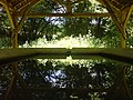 Washing-place Dégagnazès
 -
 Castel of Peyrilles
 -
 Church of Peyrilles' parish


See also
References
- ^ "Répertoire national des élus: les maires". data.gouv.fr, Plateforme ouverte des données publiques françaises (in French). 2 December 2020.
- ^ "Populations légales 2021". The National Institute of Statistics and Economic Studies. 28 December 2023.
- ^ INSEE commune file
- ^ Population en historique depuis 1968, INSEE
Wikimedia Commons has media related to Peyrilles.
| Authority control databases: National |
|---|
This Lot geographical article is a stub. You can help Wikipedia by expanding it. |
Categories:
- CS1 French-language sources (fr)
- Use dmy dates from August 2023
- Articles with short description
- Short description is different from Wikidata
- Coordinates on Wikidata
- Pages using infobox settlement with image map1 but not image map
- Pages with French IPA
- Articles containing Occitan (post 1500)-language text
- Commons category link from Wikidata
- Articles with BNF identifiers
- Articles with BNFdata identifiers
- Communes of Lot (department)
- All stub articles
- Lot (department) geography stubs
- Pages using the Kartographer extension