Paso del Sapo
Jump to navigation
Jump to search
You can help expand this article with text translated from the corresponding article in Spanish. (May 2010) Click [show] for important translation instructions.
|
Paso del Sapo | |
|---|---|
Municipality and village | |
 Paso del Sapo Location within Chubut Province | |
| Coordinates: 42°44′0″S 069°36′0″W / 42.73333°S 69.60000°W | |
| Country | |
| Province | Chubut Province |
| Department | Languiñeo Department |
| Created | 15 June 1955 |
| Time zone | UTC−3 (ART) |
| Postal code | 9201 |
| Area code | 02945 479-XXX |
| Climate | BSk |
Paso del Sapo is a village and municipality in Chubut Province in southern Argentina.[1] Its boundaries were established in 1995.[2] The Paso del Sapo Formation is named after the village.
References
- ^ "Paso del Sapo" (in Spanish). Ministerio del Interior. Archived from the original on 14 August 2015.
- ^ "Visto: El Expediente nº 01545-GB-95, el Artículo 145º de la Constitución Provincial" (PDF) (in Spanish). Ministerio del Interior. 8 August 1995. Archived (PDF) from the original on 14 August 2015.
Gallery
-
 Sign on entering Paso del Sapo
 -
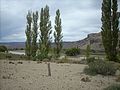
 View of Paso del Sapo
 -
 The Chubut River above Paso del Sapo


This article about a place in Chubut Province, Argentina is a stub. You can help Wikipedia by expanding it. |
Categories:
- Pages using gadget WikiMiniAtlas
- CS1 Spanish-language sources (es)
- Geography articles needing translation from Spanish Wikipedia
- Use dmy dates from August 2015
- Articles with short description
- Short description matches Wikidata
- Coordinates on Wikidata
- Populated places in Chubut Province
- All stub articles
- Chubut Province geography stubs