Parvati River (Himachal Pradesh)
This article needs additional citations for verification. (June 2016) |

Parvati River is a river in the Parvati Valley in Himachal Pradesh, northern India that flows into the Beas River at Bhuntar, some 10 km south of Kullu. It rises from the Man Talai Glacier below the Pin Parbati Pass and flows in a gradual curve from north-northwest to west-southwest past the important temple town of Manikaran.[1]
The river valley has been a route to various places: Lahul across the Sara Umga La pass, Spiti across the famous Pin Parbati Pass, and the recently discovered (1995) Debsa Pass. The river has fine first-growth forests in its upper reaches which are being degraded as a consequence of development of its vast hydro-electric potential. There are geothermal springs on the banks of the river at Manikaran and Kheerganga.
Gallery
-
 The Fast Flowing Parvati River on the banks of Kasol, Himachal Pradesh
 -
 Parvati river flowing in sweeping meanders, Kasol.
 -
 Parvati River
 -
 Parvati River, Kasol
 -
 Parvati River, Jia Bride, Kullu
 -
 River Beas and River Parvati
 -
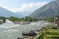
 Parvati River near Kasol town


External links
![]() Media related to Parvati River (Himachal Pradesh) at Wikimedia Commons
Media related to Parvati River (Himachal Pradesh) at Wikimedia Commons
References
- ^ Negi, Sharad Singh (1 January 1991). Himalayan Rivers, Lakes, and Glaciers. Indus Publishing. ISBN 9788185182612.
31°53′33″N 77°11′00″E / 31.89250°N 77.18333°E
| International | |
|---|---|
| National | |
| Rivers | |
|---|---|
| Lakes |
|
| Dams, barrages | |
This Himachal Pradesh location article is a stub. You can help Wikipedia by expanding it. |
- Articles with short description
- Short description matches Wikidata
- Articles needing additional references from June 2016
- All articles needing additional references
- Use dmy dates from April 2017
- Use Indian English from April 2017
- All Wikipedia articles written in Indian English
- Commons category link is on Wikidata
- Coordinates on Wikidata
- Articles with VIAF identifiers
- Articles with GND identifiers
- Rivers of Himachal Pradesh
- Geography of Kullu district
- Indus basin
- All stub articles
- Himachal Pradesh geography stubs
- India river stubs