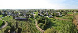
Panočiai
Jump to navigation
Jump to search
Panočiai | |
|---|---|
Village | |
 | |
| Coordinates: 54°07′08″N 24°45′50″E / 54.11889°N 24.76389°E | |
| Country | |
| County | |
| Municipality | Varėna |
| Eldership | Kaniavos (Kaniava) |
| Population (2011 Census)[1] | |
| • Total | 284 |
| Time zone | UTC+2 (EET) |
| • Summer (DST) | UTC+3 (EEST) |
Panočiai (formerly Polish: Ponacza, Russian: Понача) is a village in Kaniavos eldership, Varėna district municipality, Alytus County, southeastern Lithuania. According to the 2001 census, the village had a population of 320 people.[2] At the 2011 census, the population was 284.[1]
Etymology
The name Panočiai comes from the name of the Nočia River (i. e. means 'a place by the Nočia').[3]
References
- ^ a b "Population by locality". 2011 Population and Housing Census. Statistics Lithuania. Archived from the original (XLS) on 22 September 2013. Retrieved 10 September 2013.
- ^ "Lithuanian Population and Housing Census 2001: Alytaus County" (PDF) (in Lithuanian). Statistikos Departamentas (Lithuania). Archived from the original (PDF) on 22 September 2013. Retrieved 5 May 2010.
- ^ Šimkus, Šarūnas (2023). Varėnos krašto vietovardžių etimologinis žodynas (in Lithuanian). Vilnius: Liutauras Leščinskas. p. 47. ISBN 978-609-447-388-3.


