Old City of Luxembourg
| UNESCO World Heritage Site | |
|---|---|
 | |
| Location | Luxembourg City, canton of Luxembourg |
| Criteria | Cultural: iv |
| Reference | 699 |
| Inscription | 1994 (18th Session) |
| Area | 29.94 ha |
| Buffer zone | 108.73 ha |
| Coordinates | 49°36′40″N 6°07′48″E / 49.611°N 6.130°E |
The Old City of Luxembourg (officially City of Luxembourg: its Old Quarters and Fortifications[1]) is located mainly in Ville Haute (Uewerstad) in Luxembourg City, Grand Duchy of Luxembourg. The site was added to the UNESCO World Heritage list in 1994.[1] The origin of the city was a fort built in the 10th century and had to be demolished in most parts in the 19th century (the casemates, the bastion and some walls still exist partly). The early town (which is now the historical city) has been established in the 12th century.
Highlights are Grand Ducal Palace, Notre-Dame Cathedral, Adolphe Bridge, Dräi Tierm, Pont du Château, Chemin de la Corniche, and Bock casemates.
The Ministry of Culture, Department of National Sites and Monuments is responsible for the preservation of the sites (with a partnership of the Luxembourg Commission for Cooperation with UNESCO which was founded in 1949).[2]
Gallery
-
 Grund
Grund -
 River Alzette
 -
 Église Saint-Jean (Neumünster)
 -
 The gorges and Adolphe Bridge
 -
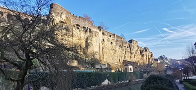 Bock Casemates (Bockfiels)

.jpg)


_2024-01-29_Mattes.jpg)
See also
List of World Heritage Sites in Luxembourg
References
- ^ a b "City of Luxembourg: its Old Quarters and Fortifications". UNESCO World Heritage Convention. 699.
- ^ https://unesco.public.lu/en/structure/commission-nationale.html
External links
![]() Media related to World Heritage sites in Luxembourg at Wikimedia Commons
Media related to World Heritage sites in Luxembourg at Wikimedia Commons
This Luxembourg-related article is a stub. You can help Wikipedia by expanding it. |